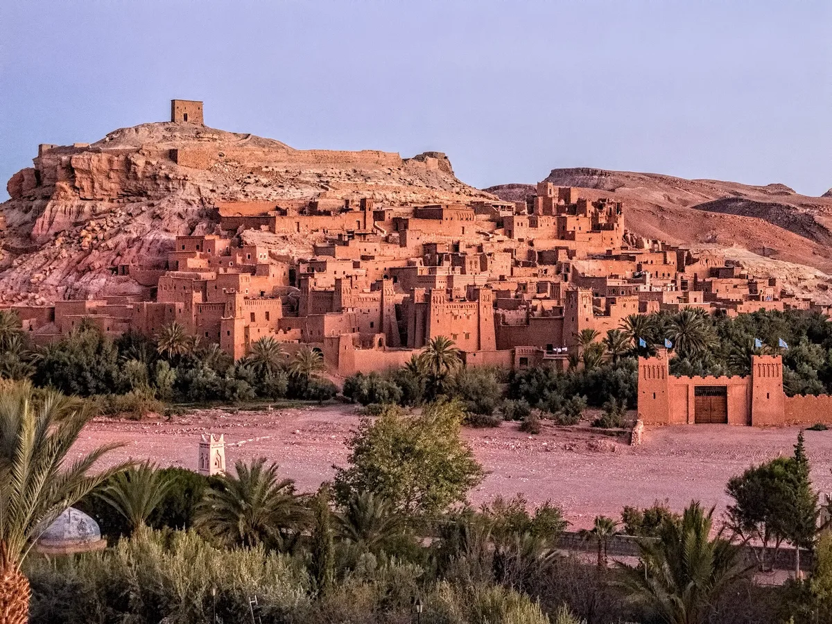
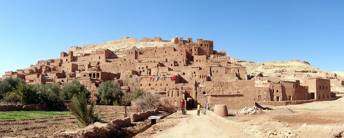
Most travellers arrive at ait benhaddou the way the caravans did – from the river. You park in the modern village, walk down through the palm groves, cross the Ounila on a footbridge or over bare stones, and the whole village rises in front of you in a single stacked eyeful – walls, towers, rooftops and a lone granary on the summit, all of it the red-gold colour of the ground it was dug from. It is one of the great first sights in Morocco, and it has been stopping people in their tracks for a very long time. Long before the film crews and the tour buses, this was a working fortress on the trans-Saharan caravan route, a place where goods, news and people changed hands between the desert and Marrakech, and where an entire community lived behind walls it had built out of mud, straw and patience.
That double identity is what makes ait benhaddou worth more than the forty minutes most visits give it. Yes, it is a film set – the most recognisable skyline in Moroccan cinema. But it is also a ksar, a fortified collective village of a type that once dotted every valley in the pre-Saharan south, and it survives more completely than any of its neighbours. UNESCO inscribed it in 1987 as the outstanding example of southern Moroccan earthen architecture, and the listing was not for a ruin. Families still live inside the walls. Houses are still replastered by hand after the rains. The granary on the hill is empty, the caravans are gone and most of the village has moved across the river – but this is a place with a present tense, and a good visit treats it that way.
This guide walks ait benhaddou the slow way. It explains what a ksar actually is and how this one is put together, how the crossing works and where the bridge leaves you, how to climb through the lanes to the granary without missing the quiet corners, what the mosque, the cemeteries and the saint’s tomb say about who lived here, and how the film years and the restoration argument have shaped what you see. It also places the village where it belongs in a journey – as the centrepiece of the Ounila Valley, a short drive from Ouarzazate and a long, beautiful one from Marrakech over the High Atlas. If you are planning the country as a whole, our Morocco travel guide sets the national picture; this page is the deep dive into its most famous village of earth.
One promise before the detail. This guide prints no entrance fees and no tour prices for ait benhaddou, deliberately. The ksar has no single gate and no fixed ticket – it is a lived-in village, not a turnstile attraction – and the small sums that change hands here, for a house visit or a local guide, are agreed on the spot and shift with the season. Any guide that quotes you an exact figure is inventing one. What follows is the mechanism, honestly described, so you can arrive knowing how the place works rather than what it supposedly costs.
Ait Benhaddou at a Glance
Here is the whole visit on one screen. The sections after this table take each row in turn.
| Question | Short answer |
|---|---|
| What is it | A ksar – a fortified collective village of earthen houses, kasbahs and towers behind defensive walls, in the Ounila Valley of southern Morocco |
| UNESCO status | World Heritage Site since 1987, inscribed under criteria (iv) and (v) as the outstanding example of a southern Moroccan ksar |
| The buildings | Nothing standing is older than the 17th century, but the site has been fortified since the 11th century and the designs are far older than the walls |
| Built from | Rammed earth (pisé), adobe and clay brick with wooden beams and lintels – no stone, no cement in the traditional fabric |
| The summit | A ruined collective granary, the agadir, crowns the hill above the houses |
| Getting in | Cross the Ounila river from the modern village – by the pedestrian bridge, or over stepping stones and the riverbed when the water is low |
| Who lives there | A handful of families remain inside the old ksar; most residents live in the modern village across the river |
| Famous for | The caravan route first, then the cameras – Lawrence of Arabia, Gladiator and Game of Thrones (as Yunkai) all filmed here |
| Nearest town | Ouarzazate, roughly 30 kilometres away; Marrakech is around 180 kilometres over the Tizi n’Tichka pass |
| How long to allow | Two hours at a minimum; half a day if you climb to the granary, linger in the lanes and stay for the light |
Two consequences follow from the table, and both are worth absorbing before you cross the river. First, ait benhaddou rewards height. The village is a vertical argument – river, walls, lanes, rooftops, granary – and nearly everything worth understanding about it is visible only once you have climbed at least halfway up it. Second, it rewards timing even more. The same lanes that feel like a film set at noon can feel like a village at eight in the morning and like a painting at six in the evening. When you come matters almost as much as whether you come.
What a Ksar Is – and Why This One Matters

Start with the word, because most visitors use the wrong one. Ait benhaddou is not a kasbah. A kasbah is a single fortified household – one powerful family’s miniature castle. A ksar (plural ksour) is the whole fortified village: dozens of households, rich and poor, gathered inside one defensive wall and organised as a single community. The distinction is visible the moment you look properly. Inside the walls of ait benhaddou, modest flat-roofed houses crowd against tall kasbahs whose decorated towers announce which families held land, animals and standing. The village is a society drawn in elevation, and the skyline is its class system.
UNESCO’s description of the Ksar of Ait-Ben-Haddou reads like an inventory of everything a ksar needed to function. Inside walls reinforced by angle towers and pierced by a single baffle gate – a gate that turns a corner on itself, so no battering rush could run straight through – the community areas include a mosque, a public square, a caravanserai for travelling merchants, grain-threshing floors outside the ramparts, two cemeteries, one Muslim and one Jewish, and the sanctuary of a local saint, Sidi Ali or Amer. Above it all, at the top of the hill, stands the fortification and loft that served as the collective granary. Nothing on that list is decorative. Each item is a department of survival – prayer, trade, food storage, burial, defence – packed onto one defensible hill above a river crossing.
Why does this ksar, of the hundreds in the Draa, Todgha, Dades and Souss valleys, carry the World Heritage listing? Partly completeness. UNESCO calls ait benhaddou a complete panorama of pre-Saharan earthen construction techniques, and an eminent example of the type under criterion (iv). Partly honesty. Under criterion (v) it represents a traditional habitat that has become vulnerable to irreversible change – which is a formal way of saying that most ksour are melting back into the ground, and this one, watched and maintained, has not. And partly it is the setting. The ksar covers just over three hectares on its hill, close enough to the river to farm, high enough to defend, and positioned on one of the few routes where caravans could cross the Atlas. Other villages had pieces of that formula. This one had all of it, and kept it.
A note on age, because the guides at the gate will give you a rounder number. The site of ait benhaddou has been fortified since the 11th century, in the Almoravid period, and the community it served is older than any standing wall. But UNESCO is precise that the oldest constructions visible today do not appear to be earlier than the 17th century. That is not a disappointment; it is the nature of earth. A village rebuilt continuously in the same designs for six hundred years is not a 17th-century fake of an 11th-century original. It is the same village, renewed – and understanding that renewal is the key to everything else in this guide.
Built of Earth – Pisé, Adobe and Towers That Need Feeding

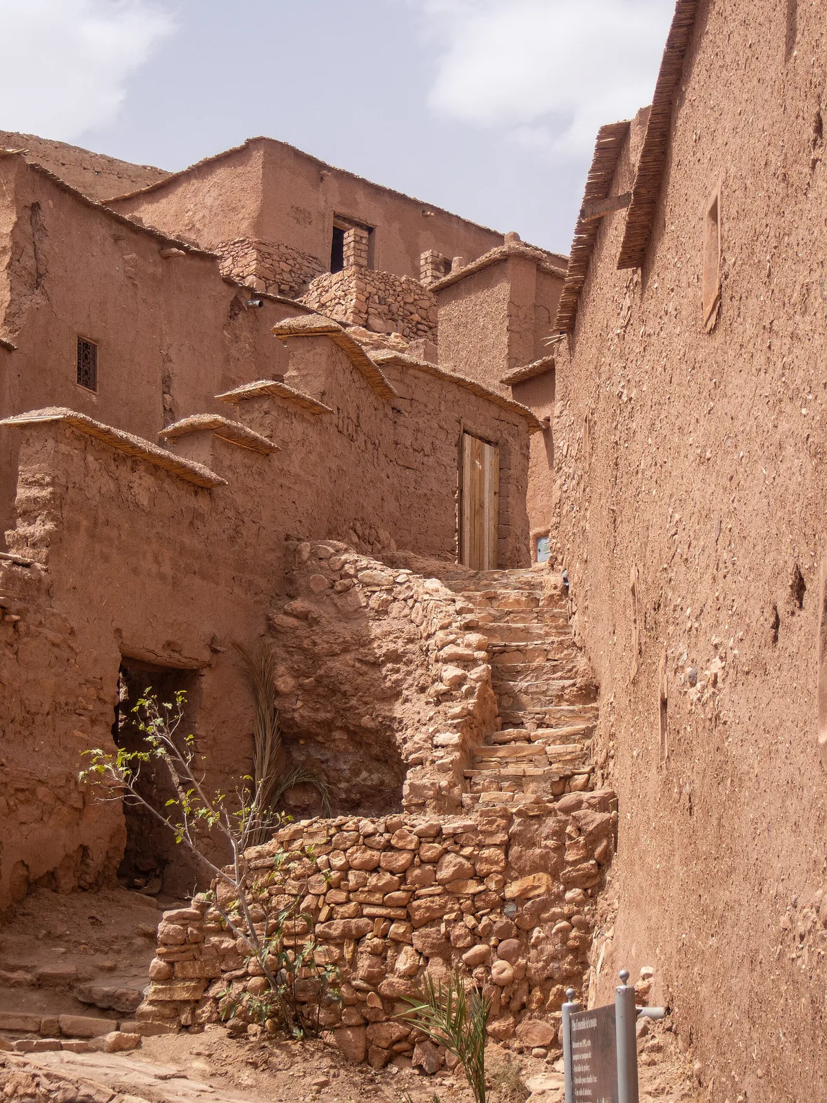
Everything at ait benhaddou is made of the ground it stands on. The primary material is rammed earth – pisé, called tabia locally – a mixture of earth, mud and straw compressed in layers inside wooden shuttering, course by course, until a wall stands. Alongside it sit adobe bricks, sun-dried rather than fired, and fired clay brick used sparingly where decoration or strength demanded it. Roofs and floors are carried on wooden beams, palm trunks and reeds. Taller buildings manage their weight with an engineer’s instinct: rammed earth up to the first floor, where the loads are greatest, and lighter adobe above. Stand in a lane and read a wall closely and you can see the whole recipe – the shuttering lines in the pisé, the straw flecks in the render, the beam ends poking out like the rungs of a ladder, ready to carry scaffolding the next time the wall needs care.
Those beam ends are the clue to the material’s one great condition. Earth is cheap, cool in summer, warm in winter and available everywhere – and it dissolves. Rain works on an unprotected earthen wall the way weather works on a sandcastle, and a building of this type, abandoned, can begin to crumble within a few decades. A ksar is therefore not built once; it is maintained forever, in an annual rhythm of patching, re-rendering and rebuilding that the whole community historically shared. The beauty of ait benhaddou is not despite this fragility but because of the centuries of hands that refused to accept it. When you see a freshly rendered facade beside a melting one, you are not looking at new and old. You are looking at kept and unkept – the two possible futures of every wall in the village.
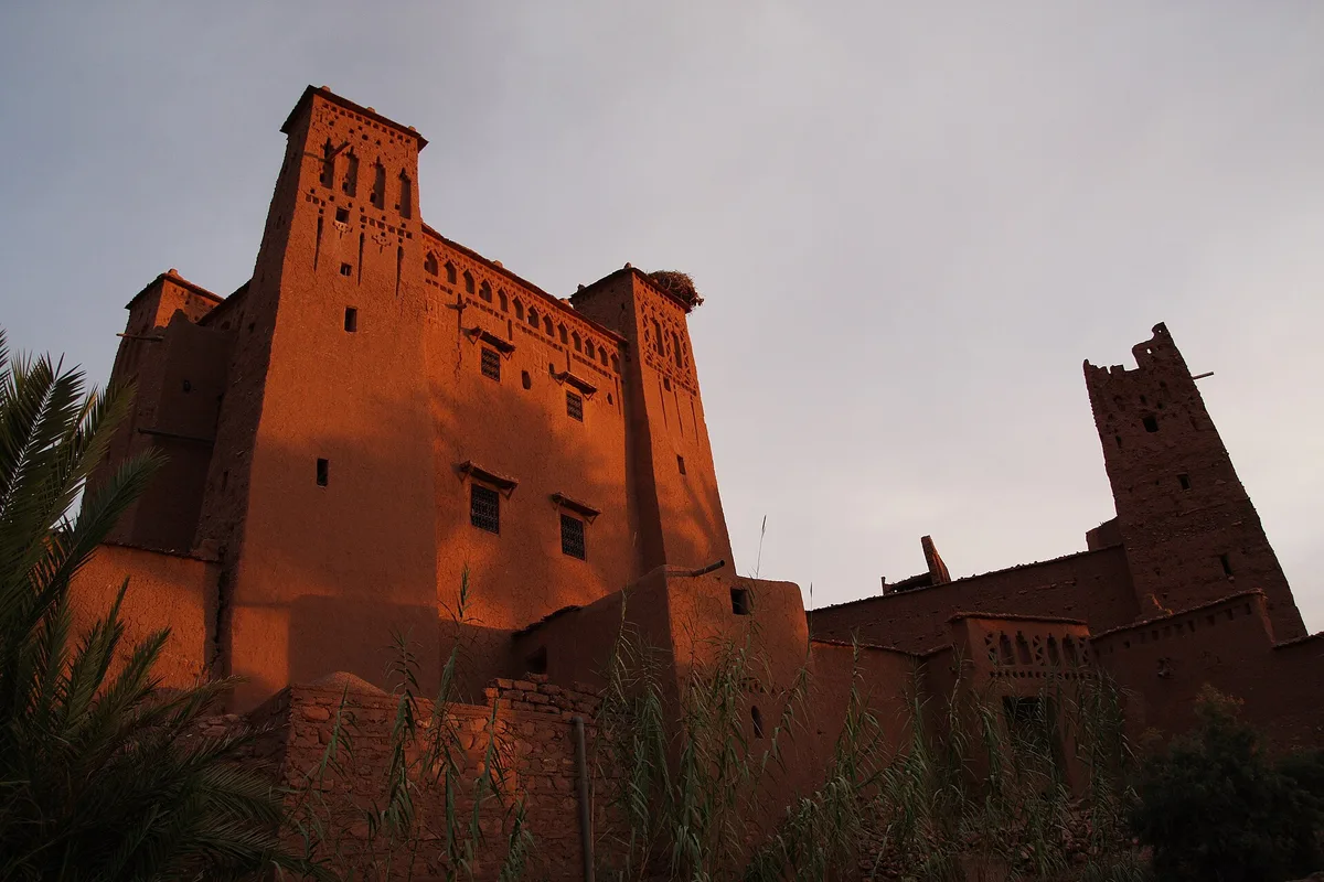
The decoration deserves a slow look, because it is where earth stops being humble. The upper sections of the great houses are worked with geometric motifs modelled in clay brick – diamonds, zigzags, stepped patterns and blind arcading, drawn from the Amazigh visual language of the south. The patterns are not applied ornament; they are built into the wall as it rises, which is why they can be renewed without being redesigned. Photograph them in raking morning or evening light, when the relief throws shadows, and the towers stop looking like mud and start looking like textiles – woven, patterned, deliberate. The finest concentration is on the kasbah towers of the lower village, which is where the next section goes.
The Kasbah Towers Inside the Walls
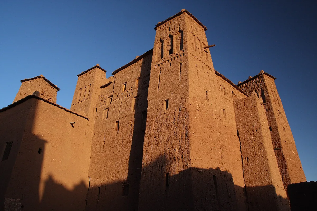
Scattered through the lower and middle village stand the kasbahs – the fortified houses of the ksar’s leading families, each one a small castle folded into the collective defences. A kasbah at ait benhaddou is typically a tall, square-planned house rising three or four storeys around a light well, crowned with corner turrets and the patterned brickwork described above. In a village of one-room and two-room houses, a kasbah was a statement in the only currency that showed – height, decoration and the labour of the builders you could command. Several of these houses were also working buildings, with storage for grain and goods at the lower levels and reception rooms above, built for a community whose wealth walked in on camels.
For the visitor, the kasbahs are where the ksar stops being a silhouette and becomes architecture. Some of the houses in the lower village are opened by their owners as small private museums or workshops – a room of tools, a loom, a roof terrace with the view the family has always had – and these visits, arranged on the spot, are among the most human encounters ait benhaddou offers. There is no ticket desk and no fixed arrangement; a door is open, a conversation happens, a small payment is agreed. Treat the houses as homes first and exhibits second, ask before you photograph anyone or anything inside, and the arrangement works the way it has always worked here – personally.
It is worth saying plainly that not every grand house is in good health. Some kasbahs stand roofless, their upper rooms open to the sky and their decorations weathering a little further each winter. The contrast is part of the site’s truth and part of its UNESCO argument: a living ksar is not a frozen one, and the same village contains restoration, habitation and slow ruin within a hundred metres of each other. The restoration section below takes up what is being done about it. For now, walk the lower lanes slowly. The kasbahs are the village’s autobiography, and they read best at walking pace.
A Fortress on the Caravan Road
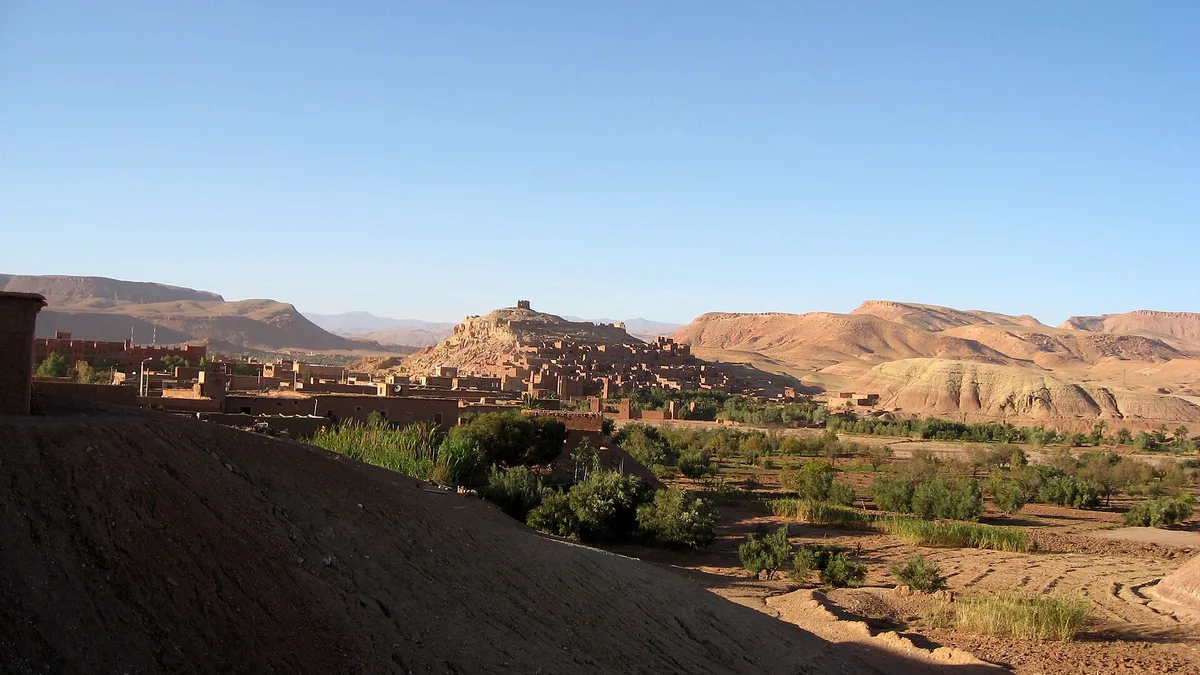
Ait benhaddou exists because of a road. For centuries, one of the great trans-Saharan trade routes ran from the desert edge up the Draa Valley, crossed the Ounila Valley at this point, and climbed through the High Atlas by the pass above Telouet to descend on Marrakech. UNESCO describes the ksar as one of the many trading posts on the commercial route linking ancient Sudan to Marrakech – “ancient Sudan” meaning the Sahelian kingdoms far to the south, the source of the gold that made Marrakech rich. Caravans came up from the desert loaded with gold, salt, spices and enslaved people – the trade’s human cargo is part of this road’s history and no honest account should tidy it away – and went back south with manufactured goods, cloth and metalwork. Every stage of that journey needed water, fodder, warehousing and safety. A fortified village above a river crossing offered all four.
Read the ksar again with the caravans in mind and its plan turns into a business model. The caravanserai received the merchants. The granary on the hill stored the community’s own food against siege and bad years alike. The threshing floors outside the walls processed the grain the valley produced. The mosque, the square and the saint’s sanctuary made the village a social and religious centre for the surrounding settlements, not just a warehouse with walls. And the toll of protection – in goods, in coin, in gifts – flowed to the families whose kasbahs still stand tallest in the lower village. Ait benhaddou was not a picturesque accident on the route. It was one of the route’s institutions.
The road died slowly, then suddenly. As maritime trade took the gold business to the coast and the caravan economy faded through the early 20th century, the Ounila Valley lost the strategic importance that had sustained its villages for a thousand years. That, more than any single event, is why the ksar emptied: UNESCO’s own integrity assessment attributes the buildings’ vulnerability to lack of maintenance resulting from the abandonment of the ksar by its inhabitants, and the abandonment followed the money. The modern road still runs the same logic in asphalt – over the Tizi n’Tichka pass at 2,260 metres, the crossing the tour buses use – while the older caravan track climbed to Telouet, where the valley’s other great kasbah stands. Both routes appear again in the combining section below. The caravans have become traffic, but the geography that made ait benhaddou has not moved.
Crossing the Ounila – Bridge, Stepping Stones and the Honest Riverbed
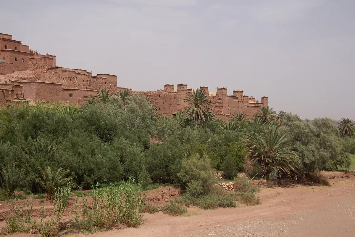
Every visit to ait benhaddou begins with a small negotiation with a river. The old ksar stands on the far bank of the Ounila from the modern village where the road, the parking and the cafes are. Between the two runs the Asif Ounila – for much of the year a modest stream spread across a wide, stony riverbed, in wet weather a genuine obstacle, and after heavy rain in the mountains occasionally a brown torrent that rearranges the crossing entirely. The river is the reason the ksar is where it is – water for the palms and fields, a moat in front of the walls – and it still edits every visit. Come prepared to treat the crossing as part of the experience rather than a delay before it.
For most of the year there are two ways across, and choosing between them is the first decision of the visit. A pedestrian bridge, completed in 2011, links the modern village directly to the ksar. It was built to make the old village more accessible and, UNESCO records, in the hope of encouraging inhabitants to move back into its historic houses. The bridge is the dry, dignified route, and it delivers you to the lower lanes. The older way is the riverbed itself – stepping stones and, when the water is low enough, simply picking a line across the stones and shallows. Generations of residents crossed this way, and on a still morning, with the ksar reflected in the film of water between the stones, it remains the more beautiful approach. It is also the one that can leave you with wet shoes, which is the river’s small print.
Honesty about the crossing matters because this is where the visit’s one persistent friction sits. The riverbank attracts offers – a hand across the stones, a donkey, a guide, a shortcut – presented as necessities and priced afterwards. None of them is a necessity. The bridge is free to walk, the stones are crossable in ordinary footwear in low water, and the ksar’s lanes, while maze-like, are small enough that getting lost in them is a pleasure rather than a problem. If you do want a local guide – and a good one genuinely adds the village’s stories to its stones – agree the arrangement and the price, in full, before you set off, on the village side of the river. That single habit converts ait benhaddou’s most transactional moment into a fair one, and the downsides section returns to it.
One more river truth, for photographers. The classic view of ait benhaddou is not from inside it. It is from the modern village’s side of the water, or from the riverbed itself, looking back at the full stack of the ksar above its palms. Take that photograph on arrival, in whatever light you have been given, because the view explains the village better than any paragraph in this guide – and then take it again when you leave, because the light will have changed its mind and so, probably, will you.
Walking the Ksar – Lanes, Gates and Dead Ends
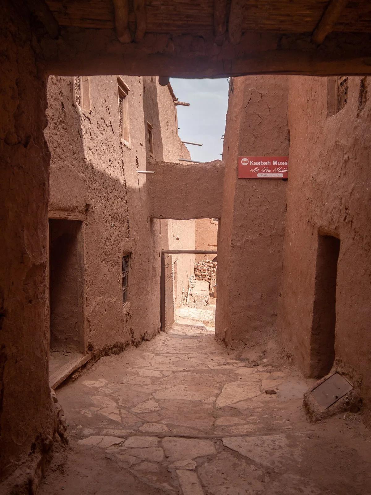
There is no route through ait benhaddou, and there never was. The ksar was built for its residents, who knew it by hand, and for defence, which prefers a maze. What a visitor gets is a hillside of lanes – some wide enough for a donkey, some shoulder-narrow, some roofed over where houses bridge them – climbing in steps and switchbacks from the lower gate to the granary, with dead ends at private courtyards and sudden openings onto terraces. Accept the maze and the visit becomes a pleasure. Fight it with a checklist and the village will feel smaller than it is. The ksar covers only about three hectares; you cannot be lost for long, and nearly every wrong turn ends at somebody’s doorway, a view, or a cat asleep in the sun.
Walk it in the order the hill imposes. The lower village, near the gate, is the commercial layer – the grand kasbahs, the opened houses, the small workshops and stalls that live off the passing trade. The middle lanes are the residential weave, quieter, with the mosque and the public square in their orbit and laundry where the tour groups rarely reach. Above them the houses thin, the lanes turn to steps, the walls of the last houses give way to open rock, and the path commits to the summit. That gradient – commerce, community, defence – is the ksar’s social order expressed as a climb, and it is the single most instructive walk in southern Morocco. Take it slowly and look backwards often; the rooftops arrange themselves into new patterns at every landing.
Practical notes, gathered plainly. The lanes are uneven, stepped and occasionally steep; this is a walk for shoes with grip, not sandals, and it is not a route for wheels of any kind. There is almost no shade except in the covered lanes, and the earth walls reflect heat back at you in summer, so carry water from the modern village – there is no reliable supply inside. Voices carry in earthen lanes; the ksar is a home before it is a monument, and a lowered voice is the entrance fee that actually matters. And when a lane delivers you to a rooftop terrace – several houses and one or two cafes maintain them – take the pause. The village reads completely differently from its own roofs.
Up on the Rooftops
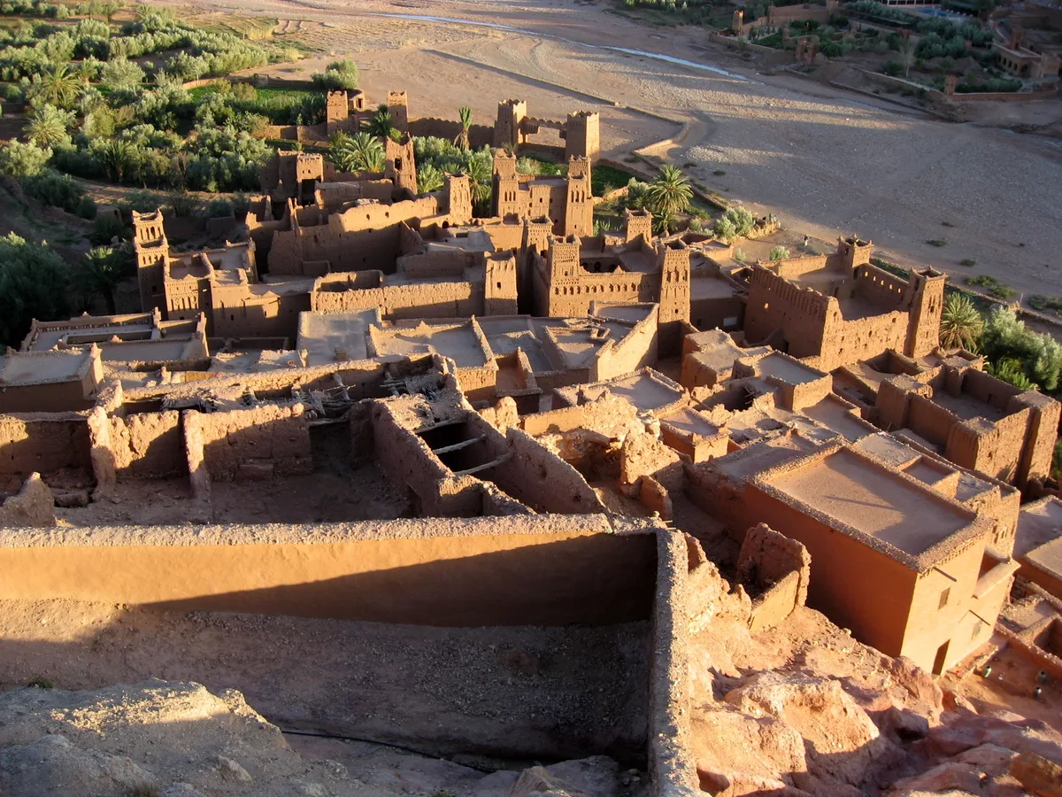
From any terrace, the ksar’s construction becomes legible as a single organism. Flat roofs of palm beams, reed matting and earth step down the hill in a cascade, each roof the ceiling of one house and the yard of none – private, load-bearing, and patched in the same annual rhythm as the walls. Look for the details that prose cannot reach: the drainage spouts that throw rainwater clear of the walls below, the small high windows that admit light without admitting heat, the granary lofts and pigeon holes worked into the gables. What reads from the river as one golden cliff resolves, from the rooftops, into hundreds of individual decisions about water, shade and weight – which is to say, into architecture.
The rooftop view also teaches the village’s one great vulnerability faster than any report. Scan the skyline and sort what you see into three conditions: rendered and crisp, weathered but whole, and open to the sky. All three states exist within a few rooftops of each other at ait benhaddou, sometimes within one house. The line between the second state and the third is a single neglected winter. Remember that scan when you reach the restoration section – it is the whole argument, visible at a glance.
The Climb to the Granary

Every ksar walk ends at the top, and ait benhaddou’s top is worth the climb. On the summit of the hill, set apart from the houses on bare rock, stand the remains of the agadir – the fortified collective granary. In the world this village was built for, the granary was the treasury. Each family kept its grain in the communal store, under collective guard, in a building positioned to be defended last and surrendered never. UNESCO’s inventory lists “a fortification and a loft at the top of the village” among the community structures, and that plain phrase undersells what you are standing in – the bank vault, food reserve and final redoubt of the entire community, wrapped in one earthen stronghold.
The building today is a dignified ruin – walls and doorways rather than a working store – and its condition is part of its honesty. But the climb buys something no state of preservation could improve: the view. From the granary, the whole geography of this guide assembles itself. Below you, the rooftops step down to the riverbed and the palm groves; across the water, the modern village spreads its flat roofs and satellite dishes; up the valley, the road winds toward the foothills and the old Telouet track; and on every side the pre-Saharan hills roll away in bands of red, ochre and grey. It is the finest viewpoint in the Ounila Valley, and it explains, in one slow turn of the head, why a village was built exactly here and nowhere else.
Time the climb with the light if you can. Early morning gives you the valley cool and the ksar’s own face in shadow below you; late afternoon gives you the long shadows and the first gold on the towers, with the walk down taken in the village’s kindest hour. At midday in summer, the summit is an exposed rock under a hammering sun, and the granary – roofless – offers no appeal for lingering. Twenty unhurried minutes at the top, in good light, will stay with you longer than anything else at ait benhaddou. It is the sentence the whole village has been climbing toward.
The Mosque, the Mellah and the Saint’s Tomb
A ksar is a community before it is a fortification, and ait benhaddou’s community buildings repay attention precisely because they are modest. The mosque sits within the lanes rather than above them – no great minaret competes with the kasbah towers – and it served, as village mosques do, as school, meeting place and clock for the settlement around it. Beside it, the public square handled the secular business of the village: markets, announcements, disputes, celebrations. Neither building shouts. In a settlement where the loudest architecture was private – those decorated family towers – the restraint of the communal buildings is itself a statement about how this society balanced the household against the whole.
The two cemeteries, Muslim and Jewish, which UNESCO lists among the ksar’s community areas, record a fact that surprises many visitors: ait benhaddou was a two-faith village. Jewish merchants were woven into the caravan economy of southern Morocco for centuries – as traders, craftsmen and intermediaries on the very routes this ksar served – and the village’s Jewish quarter, its mellah, stood within the walls alongside its cemetery. Local tradition holds the community’s roots here to be old, reaching back along the trade routes themselves. Stated carefully, that is what the evidence supports: a Jewish presence substantial enough to bury its dead in consecrated ground beside its neighbours, and a quarter remembered in the village’s own account of itself. The community departed in the great mid-20th-century emigration that emptied most of Morocco’s rural mellahs, and its houses have folded back into the village’s general fabric. The cemetery remains the clearest signature, and it deserves the same quiet respect as the graves beside it.
The third sacred presence is the sanctuary of Sidi Ali or Amer, the local saint whose tomb UNESCO names among the ksar’s features. Village saints – marabouts – were the spiritual insurance of communities like this one: a holy man’s tomb drew blessing, pilgrims and protection over the settlement, and anchored the village in a web of devotion that reached beyond its walls. Between the mosque, the mellah and the marabout, ait benhaddou’s sacred map covers the three faiths and folk practices that shared the caravan south. None of these sites is a spectacle, and none asks anything of a visitor except the obvious: dress and behave as a guest in a living religious landscape, do not enter the mosque, do not climb on graves or shrines for photographs, and let these small quiet places stay quiet.
The New Village Across the River
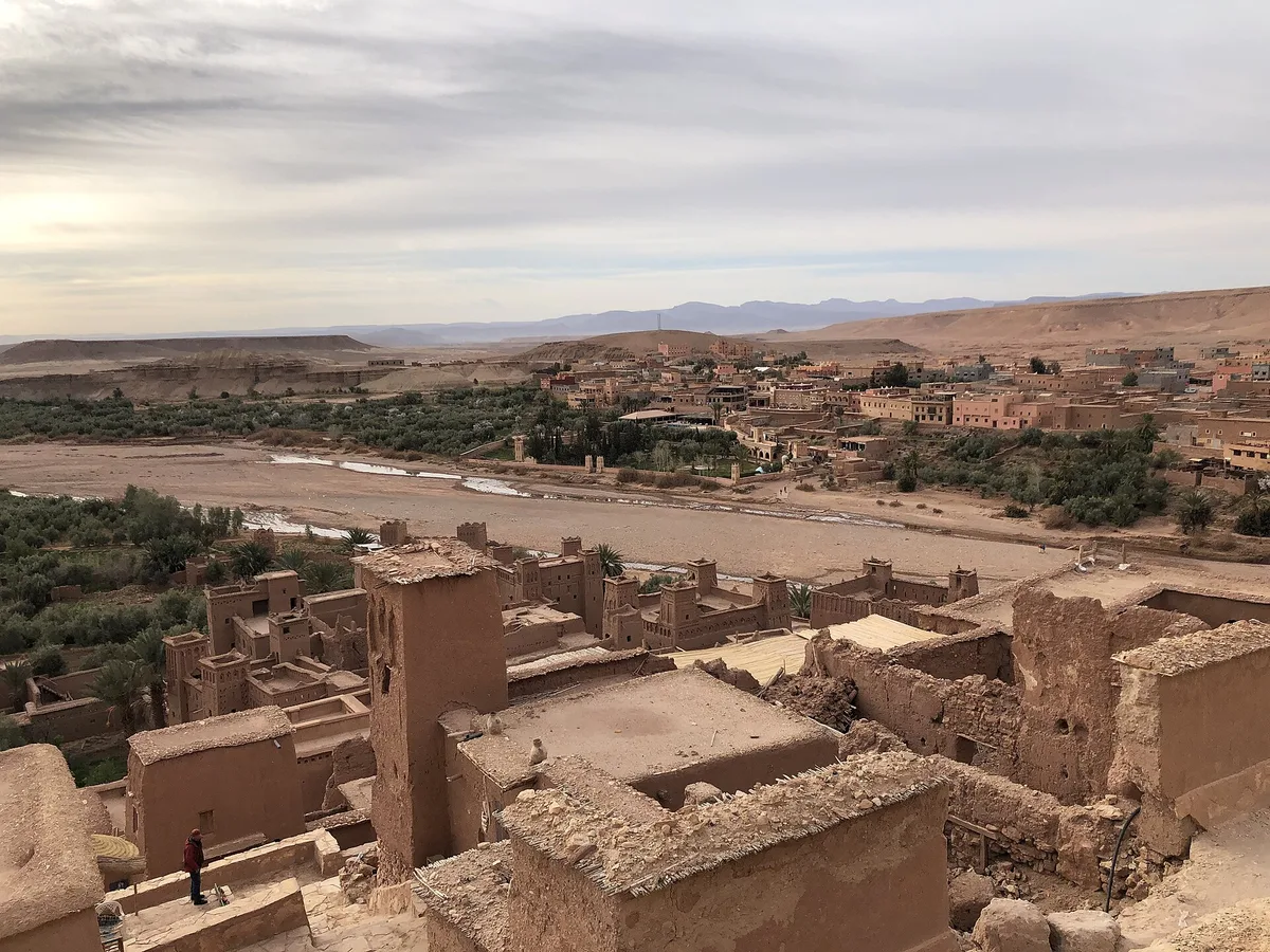
Stand on the ksar’s summit and look down, and the second half of the story is spread out across the river: a modern village of concrete and render, hotels and cafes, a mosque with a loudspeaker, satellite dishes on the roofs. This is where ait benhaddou lives now. The move across the Ounila happened household by household through the 20th century, drawn by everything the old ksar could not offer – road access, electricity, running water, schools, room to build without asking a 300-year-old wall’s permission. UNESCO’s listing documents the result plainly: the ksar itself is only sparsely inhabited today, by several families, while most local inhabitants live in the modern dwellings on the other side of the river and make their living from agriculture and, increasingly, from tourism.
It would be easy, and wrong, to read the new village as the old one’s betrayer. The families across the river are the ksar’s families. The men offering guiding at the bridge, the households opening their old houses to visitors, the builders who still know how to mix pisé and raise a wall in shuttering – they commute across the water to a heritage they no longer sleep in. The 2011 pedestrian bridge was built partly in the hope of reversing the flow, and a handful of families do remain within the walls, keeping houses, animals and presence in the lanes. Their tenancy matters beyond sentiment: an inhabited earthen house is maintained by definition, and every occupied roof at ait benhaddou is a small act of conservation that no committee can replicate.
For the visitor, the new village is infrastructure, and good infrastructure. This is where you park, where the cafes pour tea with the ksar as their wallpaper, where the hotels and guesthouses cluster for anyone staying the night – and staying the night is the single best decision a visitor can make here, as the timing section below argues. Use the modern village without embarrassment. Eat there, sleep there, take the postcard photograph from its riverbank terraces. But understand what you are looking at across the water: not a museum with a town attached, but a town that moved house, and left its old home standing, staffed and slowly weathering, on the opposite bank.
Ait Benhaddou on Screen – From Lawrence to Yunkai
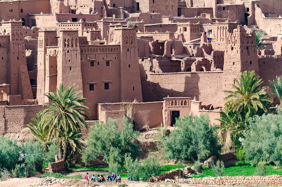
Most people have seen ait benhaddou before they have heard of it. The ksar’s second career began in 1962, when David Lean’s Lawrence of Arabia used it among its Moroccan locations, and it has rarely stopped since. The roll of productions that have filmed here reads like a history of the historical epic itself: The Man Who Would Be King in the 1970s, Franco Zeffirelli’s Jesus of Nazareth, the James Bond film The Living Daylights, The Last Temptation of Christ, Scorsese’s Kundun (for which this Moroccan village stood in for Tibet), The Mummy, Alexander, Babel and Prince of Persia. The reason is written in the architecture. Ait benhaddou belongs to no single century and several continents at once; dressed one way it is biblical, another way Roman, another way anywhere the ancient world needs a fortified town of earth under a hard blue sky.
Two productions own the modern fame. Ridley Scott’s Gladiator (2000) built its slave-market and arena town of Zucchabar against the ksar, and locals still point out where the set stood and which grandfathers were extras; Scott returned for Kingdom of Heaven. Then, in 2013, Game of Thrones arrived and ait benhaddou became Yunkai, the Yellow City of Slaver’s Bay, its gate and towers standing in the third season’s most famous establishing shots. The Thrones effect was real and lasting: a generation of visitors now arrives able to name the fictional city before the real one, and the village has absorbed this with good grace. If Yunkai is why you came, you are welcome – but know that the real city’s story, caravans and all, is older and stranger than the fictional one’s.
The film years changed ait benhaddou in ways beyond fame, and honesty requires both sides of the ledger. Credit where due: the productions brought money, work and a global audience to a village whose caravan economy had died, and UNESCO and the restoration community alike acknowledge that the Hollywood connection helped drive both the 1987 listing and the repairs that followed it. Film sets repaired walls; film fame justified budgets. But sets also altered the site – structures built for productions were left standing and have weathered into the village’s fabric, and the boundary between the 17th-century ksar and the 20th-century film set is not always where a visitor assumes. Add the pressure of the day-trip industry the fame feeds, and the picture is complete: cinema saved ait benhaddou and complicates it, in roughly the same gesture. Ouarzazate, thirty kilometres away, grew the studios – Atlas and CLA – that industrialised the trade. The ksar remains what it always was: the location that needs no building.
Restoration – Keeping a Village of Earth Alive
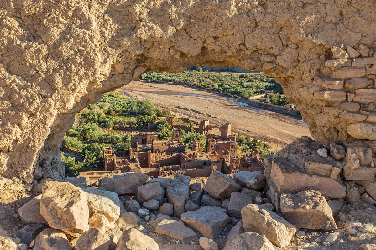
Here is the uncomfortable truth at the centre of ait benhaddou: its greatest threat is not tourism, weather or time. It is emptiness. Earthen architecture survives by maintenance, and maintenance follows habitation. As the village’s families moved across the river, the houses they left began the slow melt that UNESCO’s own assessment describes – earthen buildings “very vulnerable due to lack of maintenance and regular repair resulting from the abandonment of the ksar by its inhabitants.” A ksar does not fall down; it dissolves, one unwatched roof and one unpatched wall at a time, and whole quarters of lesser-known ksour in the southern valleys have already gone that way. Ait benhaddou’s fame has bought it a defence the others lack – a monitoring body, CERKAS, the regional centre for the conservation of earthen heritage, management committees local and national, and a rolling programme of repair in traditional materials.
The work is visible if you know how to look. Fresh render has a different colour and a cleaner edge than weathered render; new palm-beam lintels sit pale against old timber; scaffold poles lean where a wall is being rebuilt course by course in shuttering, exactly as it was first built. UNESCO notes that the ksar has preserved its architectural authenticity in configuration and materials, that the construction materials remain earth and wood, and that this is an achievement of vigilance, not luck. The September 2023 earthquake that struck southern Morocco gave the system its hardest recent test: an early assessment reported cracks and partial collapses in the ksar, with risk of further collapse, and repair of quake-damaged fabric has since joined the ordinary maintenance in the village’s workload. The ksar you visit is not a finished conservation project. It is an ongoing one, and the admission structure of the place – those small payments at opened houses, the guiding economy at the bridge – is part of how the work gets paid for.
Earth Against Cement – the Argument in Every Wall
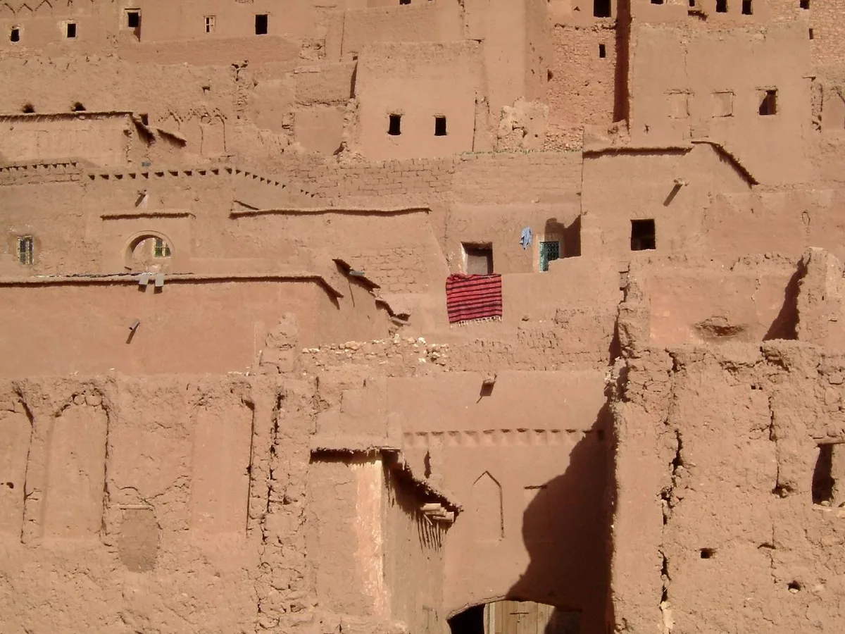
Every restoration debate at ait benhaddou reduces, in the end, to one material: cement. The temptation is obvious. Cement is cheap, fast, hard and final; earth is slow, skilled and temporary. A householder patching a roof beam or a lane wall with concrete is making a rational decision about his own winter. The conservation case is equally concrete, in the other sense: cement traps moisture inside earthen walls, accelerates their decay, breaks the building’s breathable logic and, once introduced, cannot be removed without damage. UNESCO’s assessment is strikingly direct – the inclination to introduce cement “has so far been unsuccessful,” resisted by monitoring from CERKAS and the local control committee, and the few concrete lintels that escaped vigilance “have been hidden by earthen rendering.” Read that again: the official position is that the village’s authenticity survives because people actively stop it changing into an easier material.
For the visitor, the argument has a practical upshot. The ait benhaddou you photograph is not unimproved or untouched; it is deliberately kept in a demanding traditional technique, at real cost in labour and convenience to the people who own it. That is worth money and manners. The money part is simple – the guiding fees, the house visits, the tea on a terrace are not tourist traps laid over the heritage economy; in large part they are the heritage economy, the income stream that makes earth competitive with cement. The manners part is simpler still: stay off the walls, out of the roofless houses and away from the fragile edges, because every visitor’s footprint on an earthen parapet is a small withdrawal from the same account. A village of earth asks to be looked at with the feet kept politely on the ground.
Combining Ait Benhaddou – Ouarzazate, Telouet and the Tizi n’Tichka
Almost nobody visits ait benhaddou alone, and the ksar sits at the centre of a natural day’s geometry. Thirty kilometres southeast lies Ouarzazate, the provincial capital that grew from a French garrison town into Morocco’s film city. Its own great monument, the Kasbah Taourirt, is a different animal from the ksar – a vast Glaoui palace-fortress of the 19th and 20th centuries, urban and political where ait benhaddou is communal and commercial – and the pairing of the two makes a complete short course in southern earthen architecture. Add the film studios on Ouarzazate’s edge, where sets from decades of epics stand in the desert light, and the town earns its half of the day honestly. Most organised day trips from Marrakech run exactly this combination, and for once the standard itinerary is standard because it is right.
The second pairing is better, and far fewer people make it. North of ait benhaddou, the old caravan road climbs the Ounila Valley past a chain of earthen villages – Tamdaght, with its own great kasbah, among them – to Telouet, where the Kasbah of the Glaoui, the Lords of the Atlas, sprawls in gorgeous decay: a mountain palace of painted cedars and zellige hidden inside an earthen hulk, seat of the family that once controlled this whole pass country. The valley road to Telouet is one of the most beautiful drives in Morocco, slow, winding and almost empty, and it lets a traveller do what the standard itinerary cannot – approach ait benhaddou along the route the caravans actually used, descending the valley as they did rather than arriving from the highway. From Telouet, a mountain road joins the Tizi n’Tichka route for the return to Marrakech, closing a loop that is the finest single day’s driving in the south.
Which brings up the pass itself. The modern road from Marrakech crosses the High Atlas at the Tizi n’Tichka, 2,260 metres up, in a long sequence of engineered hairpins, and the full Marrakech-to-ait benhaddou run is around 180 kilometres and the better part of four hours each way in real conditions. As a day trip it is doable and done by thousands – but it converts the ksar into a two-hour stop inside an eight-hour driving day, much of it negotiated in convoy with every other day trip in the region. The traveller who can give the journey a night – sleeping in the modern village at ait benhaddou, or in Ouarzazate – buys the two things the day trip structurally cannot: the ksar in the early morning before the buses, and the ksar at sunset after them. Our 7-day Morocco itinerary builds the village into the classic Marrakech-to-Fes route at exactly that pace, as a stop with a night in it rather than a photo break.
When to Go – Light, Heat and the Tour-Bus Clock
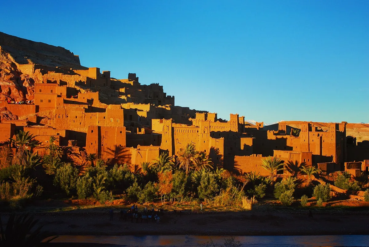
Ait benhaddou has two seasons and three times of day, and the honest answer to “when should I go” is a combination of all of them. The two seasons first. Spring and autumn are the village’s kind weather – warm days, cool nights, the river low, the light long. Winter days are mild and the crowds thin to almost nothing, though the Atlas crossing can be slowed by weather and the mornings start cold. Summer is the hard case: the Ounila Valley is pre-Saharan, the sun reflects off earth and stone, and the ksar at midday in July or August is an oven with a view. It remains visitable – thousands do it – but a summer visit should be built entirely around the early and late hours, with the middle of the day surrendered to shade, tea and the modern village’s cafes.
The three times of day matter more. Early morning, before roughly ten, is the connoisseur’s ait benhaddou: the lanes empty, the light raking across the tower decorations, the families going about a village that briefly belongs to itself, and the climb to the granary taken in cool air. The catch is logistical – a morning visit requires sleeping locally, since the first day trips cannot arrive before the light is already hardening. Midday is the tour-bus peak, when the ksar runs at capacity and the lanes around the lower kasbahs fill with groups moving at guide pace. It is not unbearable – the village absorbs a crowd better than a single monument would – but it is the version of ait benhaddou most visitors see and the least of what it offers.
Late afternoon into sunset is the great compromise, available even to the day tripper whose driver can be persuaded to linger: the groups thin, the heat breaks, and for about ten minutes the whole village turns the colour of cooling embers as the sun drops toward the hills, every tower lit like a lamp. Stay on a terrace on the modern village’s side, or better, on the granary hill itself, and watch the ksar perform the trick it has performed for every caravan that ever timed its arrival for dusk. Then the lights come on across the river, the temperature falls off a cliff, and ait benhaddou becomes a silhouette with a few lit windows – inhabited again, and entirely itself. If you take one piece of planning advice from this entire guide, take that one: be here at the end of the day.
The Honest Downsides – Crowds, Touts and Fragile Ground
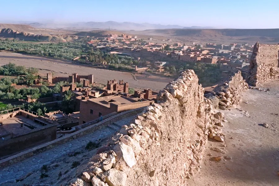
A guide that only sells ait benhaddou is a brochure, so here is the other ledger, plainly kept. The first entry is the crowd curve. The ksar is small – three hectares of lanes – and famous out of all proportion to its size, and between late morning and mid-afternoon in season it carries the full weight of the Marrakech day-trip industry at once. Groups bunch at the bridge, at the photogenic lanes and at the granary path, and the village’s spell – which depends heavily on quiet – thins accordingly. The mitigations are all in the timing section above, but they are mitigations, not cures: if you visit at noon in August, you will share ait benhaddou, and no guide can honestly promise otherwise.
The second entry is the hassle economy at the edges. The river crossing and the lower lanes attract the usual Moroccan repertoire in concentrated form: unsolicited guiding that presents itself as compulsory, offers of help across the stones with a price revealed afterwards, boys with donkeys, and shops whose owners’ enthusiasm scales with your apparent reluctance. None of it is dangerous, all of it is negotiable, and most of it dissolves under the standard defences – a smile, a clear no, arrangements and prices agreed in full before any service begins. What grates is the concentration: because every visitor funnels across one riverbed and up one set of lanes, the friction sits exactly where the wonder does. Budget a little patience for the first ten minutes and the village beyond them is, by Moroccan standards, remarkably calm.
The third entry is the ground itself. The ksar is steep, uneven, stepped and unsmoothed; its lanes were built for residents and donkeys, not for wheels, pushchairs or uncertain knees, and there is no step-free way to experience most of it. The earthen fabric is fragile in ways visitors underestimate – walls shed render under climbing hands, parapets crumble, roofless houses are unstable as well as tempting – and the site asks, reasonably, that you keep to the lanes and leave the ruins standing. Add the small honesties: there are no facilities inside the walls worth relying on, no shade worth the name at midday, and no water for sale once you are deep in the lanes. None of these are reasons to stay away. They are the terms on which a fragile, inhabited, thousand-year-old idea in mud continues to receive guests – and ait benhaddou on honest terms is worth more than a dozen easier monuments.
Frequently Asked Questions About Ait Benhaddou

Is ait benhaddou a kasbah or a ksar?
A ksar – a fortified village of many households behind one set of walls. Kasbahs are the individual fortified houses of powerful families, and ait benhaddou contains several of them inside its walls. The distinction is the whole point of the place: it is a community, not a single castle.
Is there an entrance fee for ait benhaddou?
There is no single gate, ticket office or official entrance fee for the ksar itself, because it is an inhabited village rather than a fenced attraction. Individual houses opened as small museums, and local guides, charge small amounts agreed on the spot. Anyone quoting you a fixed official price at the riverbank is inventing it.
How long do I need at ait benhaddou?
Two hours covers the crossing, the lower lanes and a taste of the kasbahs. Half a day lets you climb to the granary, walk the upper lanes, visit an opened house and still be there when the light improves. The village is small; the difference between a visit and a good visit is pace, not distance.
Do people still live in the old ksar?
Yes – a handful of families remain inside the walls, and their presence matters, because inhabited earthen houses get maintained. Most residents now live in the modern village across the river, where the road, the schools and the utilities are, and many work in the old village by day.
What films were shot at ait benhaddou?
The famous ones include Lawrence of Arabia (1962), Jesus of Nazareth, The Living Daylights, Kundun, The Mummy (1999), Gladiator (2000), Kingdom of Heaven, Alexander, Babel and Prince of Persia – and, for television, Game of Thrones, in which the ksar played Yunkai, the Yellow City, in the third season.
Can I visit ait benhaddou as a day trip from Marrakech?
Yes, and many do – but be honest about the shape of the day: around 180 kilometres and roughly four hours each way over the Tizi n’Tichka pass, which leaves about two hours at the ksar. Sleeping locally, even for one night, transforms the visit by giving you the early morning and the sunset.
When is the best time of day to visit?
Early morning for the empty lanes and the climb in cool air; late afternoon for the light, when the towers turn gold and the day trips leave. Midday in summer is the hardest slot – hottest, busiest and flattest in photographic terms.
Is ait benhaddou suitable for children and older travellers?
Children generally love it – it is a climbable-looking maze of lanes and towers, though the climbing itself must stay on the paths. For anyone with limited mobility it is a harder visit: the lanes are stepped, steep and uneven throughout, the summit climb is a real ascent, and there is no step-free route through the old village.
The Short Version of Ait Benhaddou
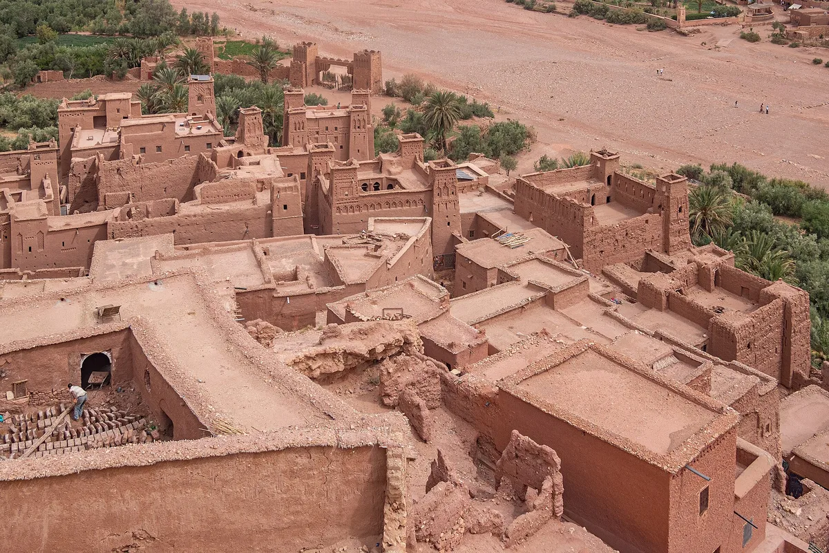
Ait benhaddou is Morocco’s most complete ksar – a fortified village of rammed-earth houses and decorated kasbah towers behind walls and a corner-turned gate, standing over the Ounila river on the old trans-Saharan caravan route between the desert and Marrakech. It has been fortified since the 11th century, rebuilt in earth ever since, and recognised by UNESCO in 1987 as the outstanding example of its kind. Cross the river by the footbridge or the stepping stones, climb the lanes from the great houses of the lower village to the collective granary on the summit, look at the mosque, the two cemeteries and the saint’s tomb that made it a community, and look back across the water at the modern village where that community now mostly lives. Remember that the cameras found it honestly – Lawrence of Arabia, Gladiator and Yunkai are all really here – and that the earth it is built from survives only because people keep repairing it, in earth, against every temptation of cement. Come early or stay late, agree every price before every service, keep your feet off the walls, and give it half a day rather than the hour the buses allow. That is ait benhaddou, and there is nothing else in Morocco quite like it.