Most Roman cities in the Middle East survive as a temple here, a theatre there, a street of columns running into a modern road. Jerash is different in kind, not just in degree. Drive forty minutes north of Amman and an entire provincial capital of the Roman Empire is still standing in its valley – its triumphal arch, its racetrack, its oval forum, its 800-metre main street, two temples, two theatres and a small crowd of mosaic-floored churches, arranged along one walkable line, with the living Jordanian town that shares its name watching from the opposite hill. This jerash travel guide walks that line in the order you will walk it yourself, from the arch outside the walls to the gate at the far end, and then deals honestly with everything around the walk – the town, the seasons, the day-trip arithmetic, and the downsides nobody puts on a brochure.
The ancient name is Gerasa, and the scale of what survives is the first thing to get straight. Gerasa was one of the ten cities of the Decapolis, the league of Hellenistic cities that flourished under Roman protection east of the Jordan, and at its peak it held some 80 hectares inside its walls. Jordan’s own tourism board calls Jerash a close second to Petra on the list of favourite destinations in the country, and describes the site as one of the best-preserved Roman provincial towns in the world. That is not marketing inflation. What other Roman cities keep in fragments, Jerash keeps in systems – you can follow the water from the fountain to the drains under the street, and the traffic from the starting gates of the hippodrome to the wheel ruts in the paving.
One piece of honesty belongs at the front of this jerash travel guide, because Jerash is often mislabelled in print. Jerash is not a UNESCO World Heritage Site. It sits on UNESCO’s Tentative List – Jordan submitted it in January 2004 under the name “Jerash Archaeological City (Ancient Meeting Place of East and West)” – which means it is a candidate under consideration, not an inscribed property. Jordan has eight inscribed World Heritage properties, and this is not yet one of them. The ruins lose nothing by the distinction, but you deserve to have it straight, and the FAQ at the end returns to it.
The visit has a natural shape and this guide follows it. You enter at the south, where Hadrian’s Arch and the hippodrome stand outside the walls, pass through the South Gate into the Oval Plaza, and then walk the Cardo north past the fountain, the cathedral steps and the great temples to the second theatre and the far gate. Allow half a day at the very least. The sections after the walk cover the modern town across the wadi, pairing Jerash with Ajloun Castle and Amman in a single day, the Jordan Pass, the right season – and the real drawbacks, which are mostly made of sunshine.
| Question | Short answer |
|---|---|
| What is Jerash | Ancient Gerasa, a Decapolis city 48 km north of Amman and one of the best-preserved Roman provincial towns anywhere |
| UNESCO status | Tentative List only, submitted by Jordan in 2004 – not an inscribed World Heritage Site |
| The walk | South to north in one line – Hadrian’s Arch, hippodrome, South Gate, Oval Plaza, Cardo, temples, theatres, North Gate |
| The street | The Cardo Maximus, 800 m of original paving with chariot ruts, lined with columns and shops |
| Signature sights | The oval forum, the Temple of Artemis with eleven standing columns, the South Theatre’s acoustics, the Cosmas and Damian mosaic floor |
| The show | Roman army and chariot re-enactments are staged in the hippodrome – check the day’s schedule at the visitor centre |
| Getting in | Admission to the archaeological city is included in the Jordan Pass; ordinary tickets are sold at the site |
| Best months | March to May for wildflowers and mild air; September to November for warm light without the furnace |
| Pair it with | Ajloun Castle to the west, or Amman’s Citadel – one northern day, planned in the pairing section below |
| One honest warning | There is almost no shade anywhere on the site, and by late morning in summer the stone itself feels heated |
From Greek Gerasa to the Roman Golden Age
People have lived in this valley far longer than Rome has existed. Settlement at Jerash reaches back to the Neolithic – human remains found here date to around 7500 to 5500 BC – and there was a Bronze Age presence in the hills long before anyone spoke Greek. The city that concerns us begins with the Hellenistic world that followed Alexander the Great. Greek inscriptions preserve its name as Gerasa and its grander title as Antioch on the Golden River, the river being the stream in the wadi below, which the Greeks called the Chrysorrhoas. Tradition credits Alexander himself, or his general Perdiccas, with settling aged Macedonian soldiers here in 331 BC; other evidence points to a founding under the Seleucid king Antioch IV, and still other accounts to Ptolemy II of Egypt. The honest summary is that Gerasa was a Hellenistic foundation of the centuries after Alexander, Greek in its institutions and language, planted in a Semitic countryside that had its own older gods – a dual inheritance you can still read in its two great temples, as the sections below explain.
The Hellenistic city had a turbulent last century. In the early 80s BC the Hasmonean king Alexander Jannaeus besieged and took Gerasa, folding it into the kingdom of Judaea. That episode ended in 63 BC, when the Roman general Pompey conquered the region and reorganised it. Gerasa was attached to the Decapolis, the league of ten Hellenistic cities that kept a large measure of self-government under Roman protection, minted their own coins and shared a calendar that began with Pompey’s arrival. The historian Josephus, writing of the Jewish revolt a century later, noted Gerasa as a largely Syrian city that refused to harm its Jewish residents and even escorted those who wished to leave safely to the border – a small, decent footnote in a brutal war. It was also the birthplace of Nicomachus of Gerasa, the mathematician whose writings on arithmetic and music were still being studied a thousand years later.
Rome’s peace was the making of the place. In the second half of the first century AD Gerasa grew rich on the trade that crossed northern Jordan, and in AD 106 the emperor Trajan absorbed the region into the new Roman province of Arabia, alongside Philadelphia – modern Amman – Petra and Bostra. Trajan’s administration built roads through the province, security improved, and more trade came up the valley. The wealthy citizens of Gerasa did what wealthy citizens did everywhere in the Roman East – they competed to give their city monuments. Inscriptions record an almost complete circuit of city walls finished by AD 75-76, and across the following century the Gerasenes raised the theatres, temples, colonnaded streets and fountains this jerash travel guide walks through, most of them paid for by private generosity rather than imperial command. The climax came in the winter of AD 129-130, when the emperor Hadrian himself visited, and the city built him the great arch you still pass on your way in. A provincial town that could host an emperor, and build like this, was not on the edge of the Roman world. For a few generations, it was one of the places the Roman world was proudest of.
The Earthquake, the Long Burial and the Rediscovery
Gerasa’s second act was Christian. A large Christian community grew up in the late Roman city, a cathedral rose in the fourth century, and at least fourteen churches followed between the fourth and seventh centuries, several of them built over or beside the pagan temples they replaced. The city’s misfortunes began with other people’s wars. The Persian Sassanids invaded in AD 614, and in 636, after the Muslim victory at the Yarmuk, Gerasa passed into the caliphate. Contrary to the tidy story told about many ancient cities, that was not the end. Under the Umayyad caliphs Jerash flourished again – it had shops, workshops and its own mint striking coins in its Arabic name, its potters produced lamps stamped with the maker’s name and the name of Jerash, and a mosque stood alongside churches that remained in use. Muslim and Christian communities lived in the same streets, and the city the archaeologists found is as much Umayyad as it is Roman.
What ended Jerash was the ground itself. In 749 a devastating earthquake – the great Galilee earthquake of that year – destroyed much of the city, and later shocks added to the damage. Gerasa shrank and faded. In 1120 a garrison of the atabeg of Damascus built a small fort among the ruins; Baldwin II of Jerusalem captured and burned it the following year, and after that the site was effectively deserted, its fallen columns slowly silting over. An Ottoman tax register of 1596 counts Jerash at twelve Muslim households, though archaeologists have since found a small Mamluk hamlet tucked into the Northwest Quarter, so the abandonment was never quite total. For the outside world, the city simply vanished from the record until the German traveller Ulrich Jasper Seetzen identified the ruins in 1806 and recognised what they were.
Modern Jerash begins with farmers, not archaeologists. Circassian families from the Caucasus began settling the east bank of the wadi in 1878, and the Ottoman authorities settled further Circassian immigrants there in the 1880s, giving the new village arable land among and around the ruins. The newcomers farmed the valley while the ancient city slept on the opposite hill, largely undisturbed because the settlement grew on the far side of the stream. Systematic excavation began in 1925, and through the late 1920s and 1930s joint expeditions cleared the streets and temples you walk today; work has continued, in campaigns by Jordanian and international teams, ever since, and parts of the eastern quarters of Gerasa are still being uncovered. The arrangement that resulted is the one you see – a fenced archaeological park on the west bank, preserved precisely because the living town grew up somewhere else.
Hadrian’s Arch, the Monument Before the City
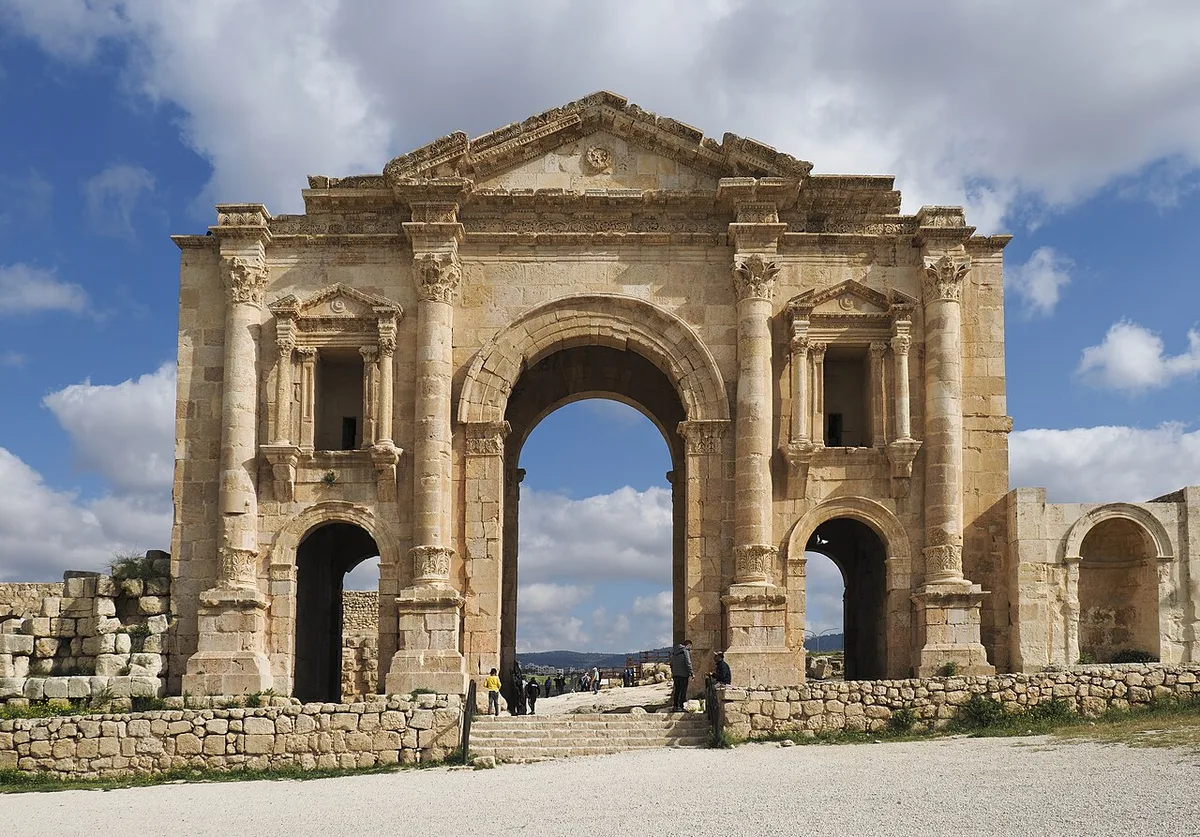
Your visit starts outside the ancient city, and that is deliberate – it started there in antiquity too. Several hundred metres south of the city walls stands the Arch of Hadrian, a triple-arched gateway of honey-coloured stone with engaged columns, carved niches and acanthus-leaf column bases unlike anything else in Jordan. It was built to commemorate the most important weekend in Gerasa’s history – the emperor Hadrian’s stay in the city in the winter of AD 129-130, during his long tour of the eastern provinces. An emperor’s visit was the ancient equivalent of a royal tour and an investment summit combined, and Gerasa marked it in the most public way available, in stone, on the road every traveller from the south would use.
The arch also carried an ambition that failed, which is what makes it poignant as well as grand. It was intended, in time, to become the city’s main southern gate – Gerasa planned to expand southward until its walls reached out and swallowed the monument. The expansion was never completed, the walls never came, and so the arch has stood alone in its field for nineteen centuries, a front door to a suburb that was never built. Jordan’s tourism board notes the unfulfilled plan plainly, and once you know it, the arch reads differently – not as a ruin of something finished, but as a promise a rich city made to itself at the very height of its confidence.
Today the arch is the natural overture to the site. The modern visitor facilities stand nearby, and the approach road passes the hippodrome on the way to the South Gate, so the walk in already teaches you the city’s geography. Give the arch a few minutes rather than photographing it from the car park. Stand under the central arch – the side passages are for pedestrians, the great central opening was for ceremony and carriages – and look north. Everything in this jerash travel guide lies through that opening and up the gentle slope beyond it.
The Hippodrome and the Ghost of the Races
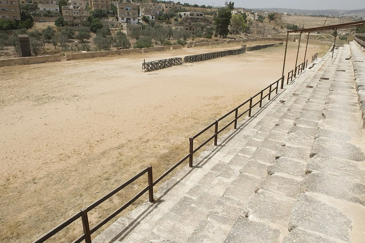
Between Hadrian’s Arch and the city wall lies the building that tells you most about how Gerasa spent its leisure – the hippodrome, the stadium for chariot racing. By the figures Jordan’s tourism board publishes, it measures 245 metres long and 52 metres wide and could seat some 15,000 spectators, which makes it a serious piece of entertainment infrastructure for a provincial city – and a compact one, small enough that from the top of its seating bank you can read the whole arena at a glance. Its exact construction date is genuinely uncertain; the tourism board’s estimate runs from the middle of the second century to the third century AD, and this guide will not pretend to a precision the evidence does not support.
What survives makes the mechanics of race day easy to reconstruct. At one end stood the carceres, the starting gates from which the chariots – two-horse and four-horse teams – burst at the drop of a cloth; the vaulted seating rose around the long sides, and the racing surface was sand over the central spine the cars circled lap after lap. The building outlived its sport by centuries, and not gloriously. From the fourth century the racing faded, and in later periods the vaults under the seats were given over to workshops and dwellings – potters worked in the shadow of the stands where the crowd had roared, which is a fair one-sentence history of the late antique city.
The hippodrome is also where Jerash stages its most theatrical piece of living history. A company called the Roman Army and Chariot Experience – RACE – performs re-enactments in the arena: legionaries in armour demonstrating drill and battle formations, gladiator bouts, and chariot races run over a classical seven-lap course around the arena. Jordan’s tourism board lists the show among the site’s attractions and describes the re-enactments as regular, and recent seasons have seen the performances running. Schedules, though, are not something this guide will fix in print – performance days and times shift with the season, and the show has known interruptions. Treat it the way the locals advise – ask at the visitor centre when you arrive, and expect the show, when it runs, to be ticketed separately from your site entry. If a race is on during your visit, take the chance. There is nowhere else in Jordan where the building and the spectacle it was built for occupy the same ground on the same afternoon.
The South Gate and the Way In
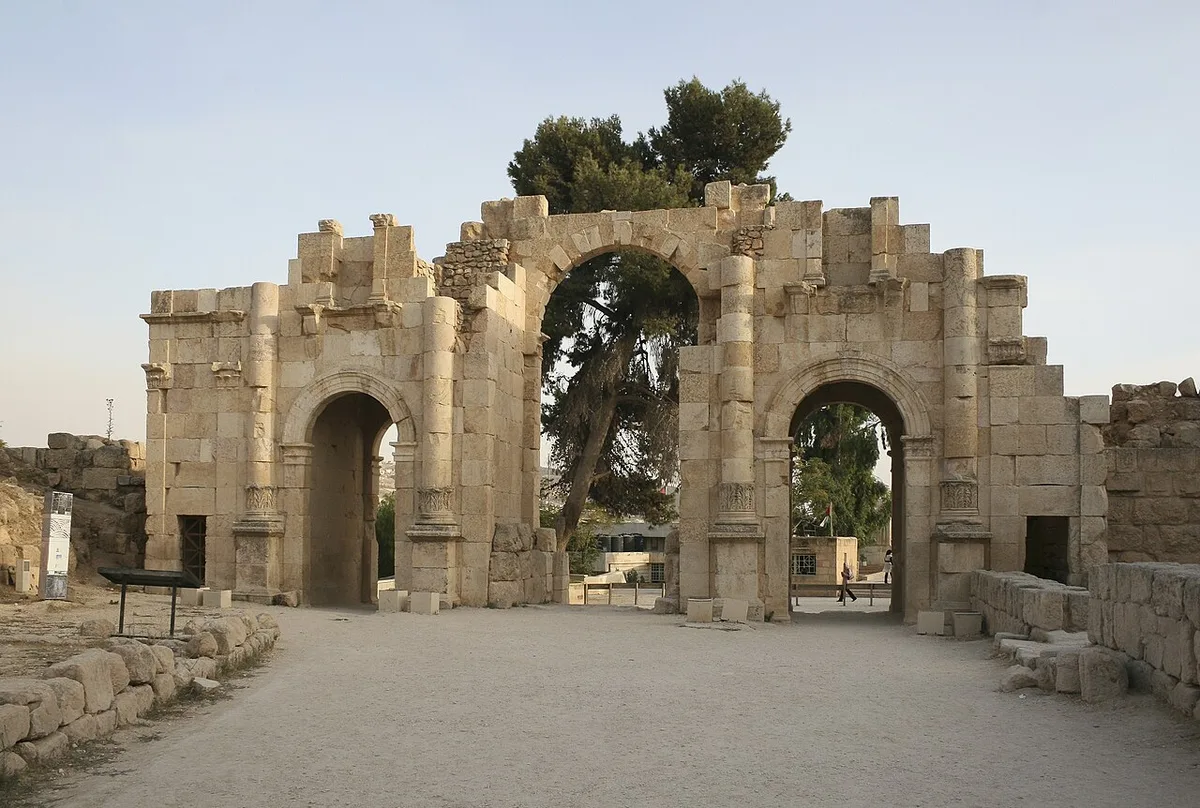
The city proper begins at the South Gate, the working entrance in the southern stretch of Gerasa’s walls. The gate is usually dated to around AD 130 – the same building moment as Hadrian’s visit – and it is best understood as Hadrian’s Arch translated into a plainer, functional dialect: the same triple-arched idea, one broad passage for wheeled traffic flanked by passages for people on foot, but built to be used rather than admired, and later bound into the wall circuit that protected the city. Gerasa’s walls, whose course can still be traced around most of the ancient city, turned the monumental gateway into a checkpoint, and everyone who entered Roman Jerash on business passed under these arches.
Pause just inside, because the South Gate frames the single best first impression in Jordanian archaeology. You do not enter a ruin field. You enter a city at its front door, and the door opens directly onto a forum – not a jumble of foundations but a paved public square ringed with standing columns, with the main street running away beyond it and a temple on the hill above. Everything the Romans meant by civic life is in that one view, and it is worth standing still for it before the tour groups behind you fill the frame.
The Oval Plaza, a Forum That Refuses to Be Square
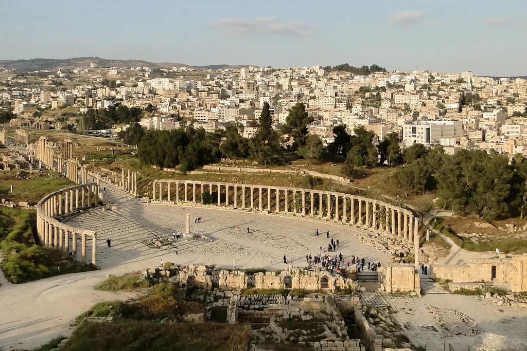
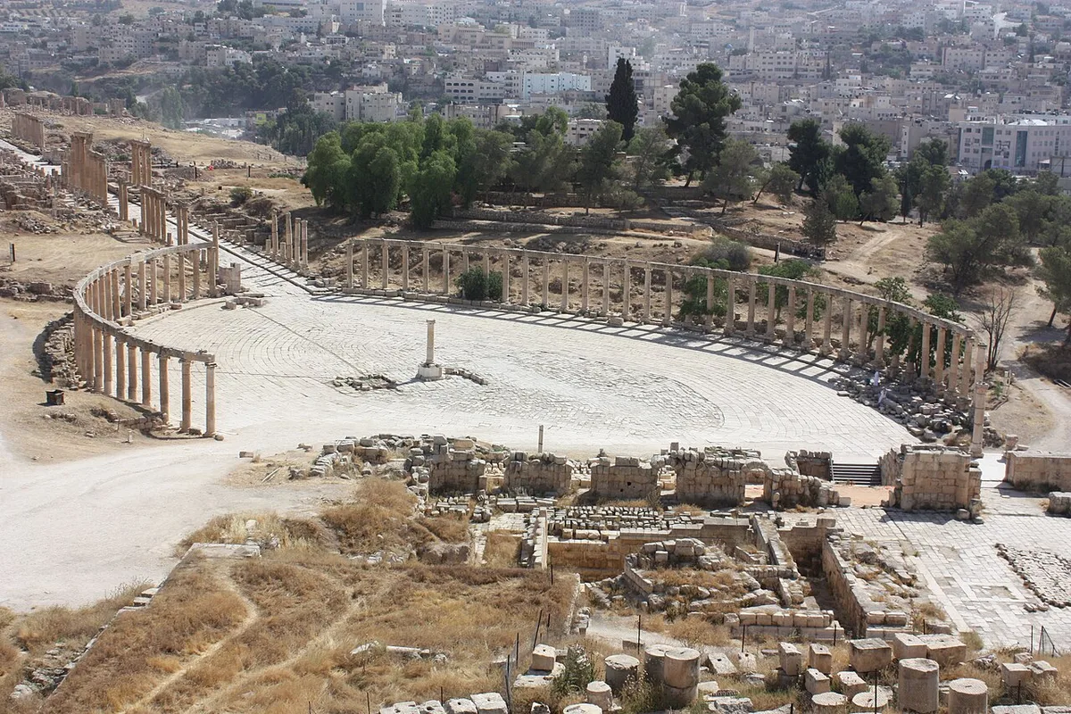
Roman forums are supposed to be rectangular. Gerasa’s is an oval, and the oddity is the point. The Oval Plaza measures 90 metres by 80, is paved throughout, and is ringed by a colonnade of Ionic columns – fifty-six of them by the usual count – dating to the first century AD. Two altars stood in the middle, a fountain was added in the seventh century when the city was already Christian and then Umayyad, and the square structure at the centre today carries a column erected to hold the flame of the modern Jerash Festival, lit here each summer. It is a working public room that has been re-purposed by every age that used it, and its paving still does the job it was laid for.
The shape is a piece of urban diplomacy. The sanctuary of Zeus on the hill to the west and the Cardo, the main street, running north, do not sit at the tidy right angle a rectangular forum would demand – the two axes meet at a skew. A rectangular plaza would have advertised the misalignment; an oval dissolves it, sweeping the eye and the pedestrian around the curve and out onto the street without ever presenting a corner where the geometry goes wrong. It is one of the most intelligent pieces of planning in the Roman East, and one of the very few oval forums anywhere.
Practically, the plaza is where your sense of the visit’s scale should settle. From its centre you can see the whole southern city – the Zeus temple above you, the South Theatre in its hollow to the west, the colonnade of the Cardo running north like a ruled line. This jerash travel guide returns to the plaza at the end of the walk in spirit, because it is the right place to finish too: come back down the Cardo in the late afternoon and the oval fills with long light and lengthening shadows, and the forum becomes what it was, the front room of the city, with the whole population of the day passing through it.
The Cardo Maximus, 800 Metres of Working Street
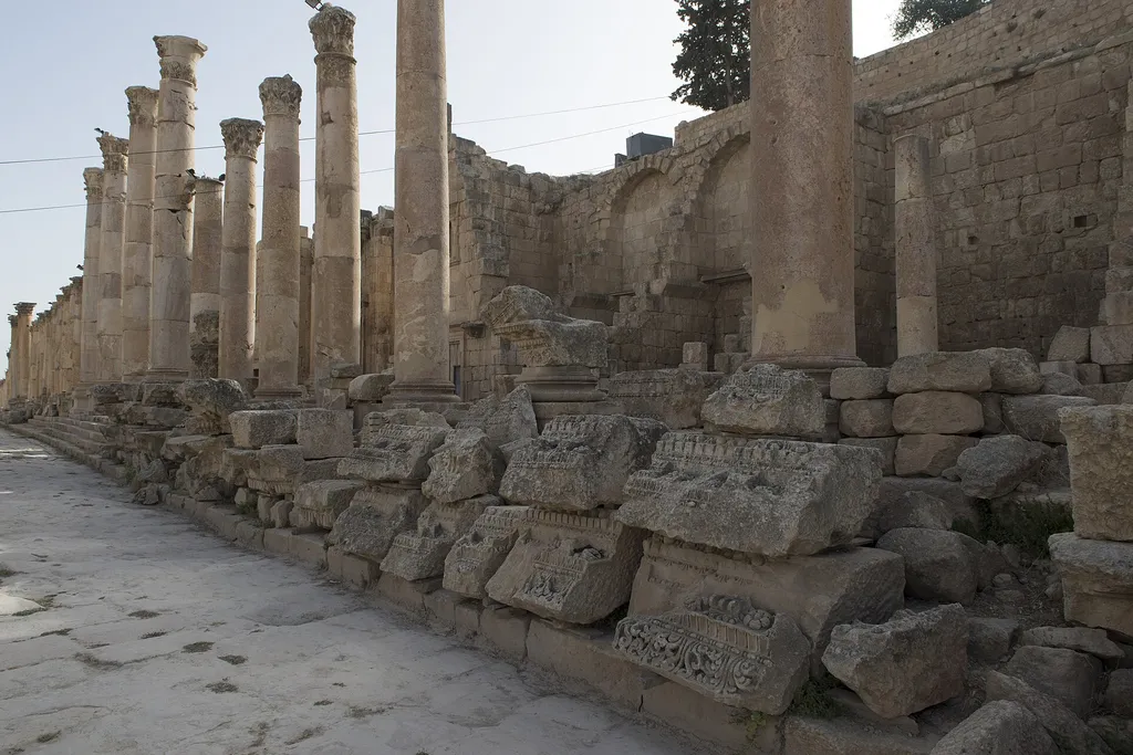
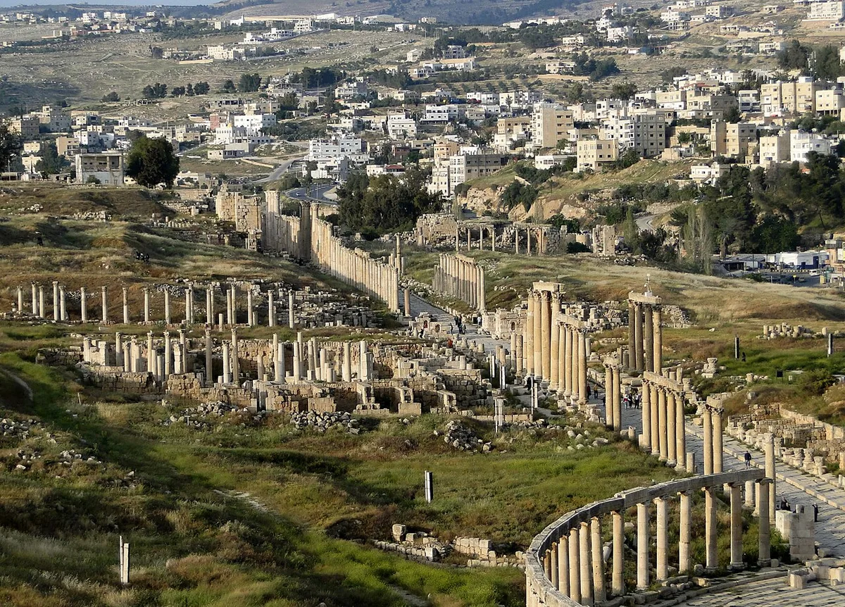
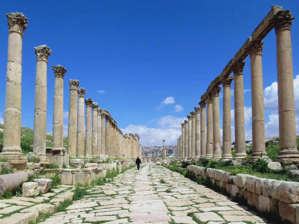
Every Roman city had a main street, but very few still have theirs. Gerasa’s Cardo Maximus runs some 800 metres from the Oval Plaza to the North Gate, and it runs on its original paving – great slabs of stone laid diagonally, the better for cart traffic to grip and turn, and worn by centuries of iron-rimmed wheels into visible ruts that your feet can find as you walk. Beneath the street, for its full length, ran an underground sewer, and the regular holes at the edges of the roadway are the drains that carried rainwater down into it. It is not a ceremonial avenue that happens to survive. It is a piece of municipal engineering – road, drain, pavement and shopping street in one – that survived because the city died before anyone could improve it away.
The columns tell the street’s biography. The Cardo was first colonnaded in the first century AD, when the street was dressed in the plainer Ionic order. In the late second century – the remodelling is usually placed after about AD 170 – the city widened its main street, repaved it, and rebuilt the colonnades of the grand central stretch in the taller, leafier Corinthian order, the columns deliberately varied in height so that the portico line would set off the facades of the buildings behind them. Walk north and the change happens around you: the showpiece Corinthian centre gives way, toward the northern end, to the older and smaller Ionic columns of the Trajanic-Hadrianic street, closely spaced and modest by comparison. One street, two centuries of taste, legible at walking pace.
Behind the porticoes ran broad sidewalks and the frontages of the city’s commercial life – shops, workshops and public buildings, most now foundations, but the arrangement needs no imagination to restore. Midway along the west side, a colonnaded courtyard marks the Macellum, the city’s food market, its central fountain ringed by the stalls where Gerasa bought its dinner. Two cross-streets, the decumani, cut the Cardo at monumental four-way junctions called tetrapyla, and the greatest monuments – the fountain, the cathedral steps, the processional entrance to the Temple of Artemis – all address themselves to this street, because this street was the city’s public face. Of the more than five hundred columns that once lined it, a remarkable share still stand or have been re-erected. Walk it slowly. It is honest about what it was: not a monument, but the place where a city of perhaps tens of thousands did its daily business in the shade of a colonnade.
The Nymphaeum, Water as Public Theatre
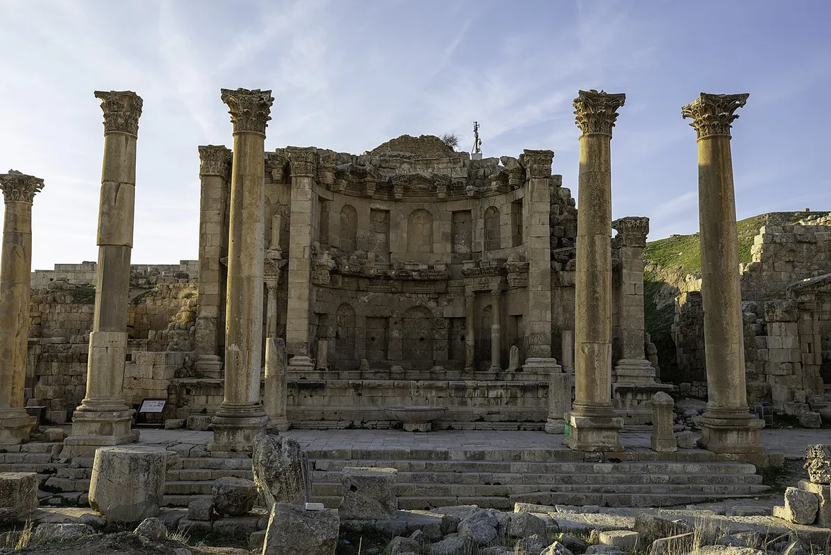
Halfway up the Cardo’s west side, the street opens onto the most purely delightful building in Gerasa – the Nymphaeum, the city’s monumental public fountain, constructed in AD 191 and dedicated to the water nymphs. It stood two storeys high: the lower level faced in marble, the upper in painted plaster, the whole composition crowned by a half-dome and organised around niches that once held statues. Water brought down by aqueduct from the hills cascaded through seven carved lions’ heads into basins at pavement level, and the overflow ran away through drains into the sewer beneath the street. In a landscape that is dry for half the year, this was water spent on display – a fountain as a piece of civic boasting, proof that Gerasa could afford to make its water supply beautiful.
Buildings like this are where Roman urbanism shows its values most clearly. The Nymphaeum is not a temple and not a bath; it is a refreshment stop and a piece of street theatre combined, placed exactly where the shopping street’s crowd was thickest, so that the gift of water reached the maximum number of citizens – the ancient equivalent of a landmark fountain in a modern square, except that this one also watered the city. Stand in front of it and read the facade as the advertisement it is: Gerasa was rich, Gerasa was engineered, Gerasa looked after its people. Then look at the lion-head spouts and the empty basins, and remember that the performance ended when the aqueducts failed and the city above them shrank. The fountain is the high-water mark of the place, in every sense.
The Cathedral Steps and the Fountain Court
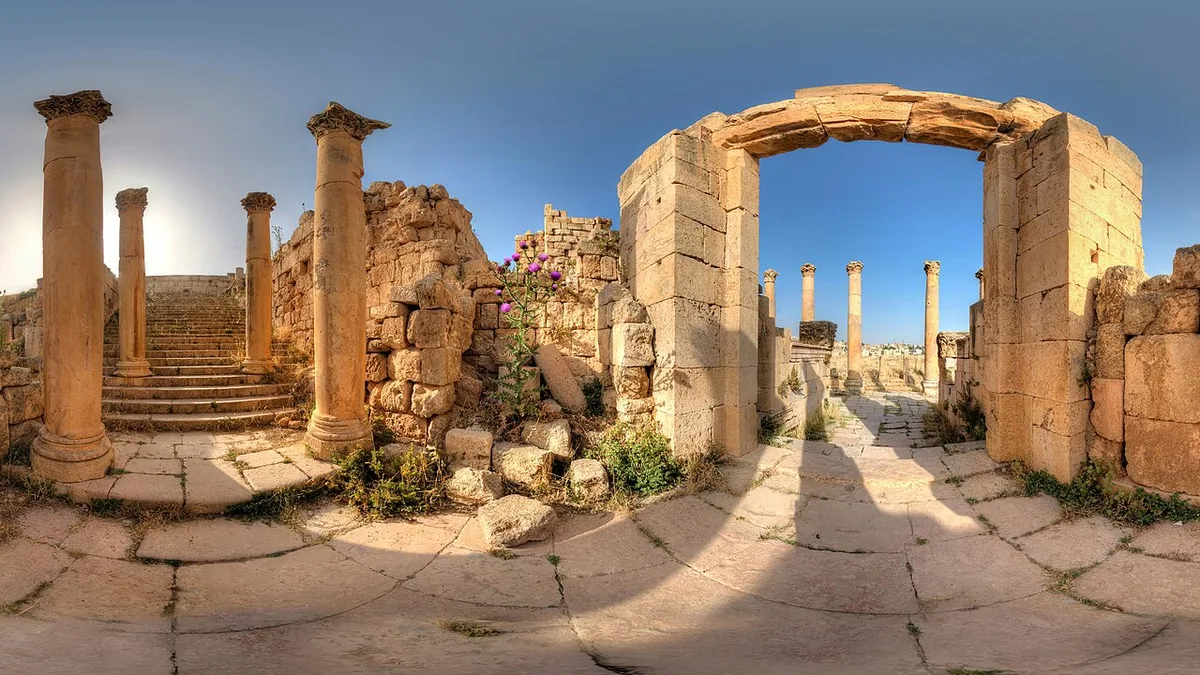
A few steps north of the Nymphaeum, the Cardo presents you with the most richly carved doorway in the city, and behind it, the clearest evidence that Gerasa had a second, Christian life as long and serious as its pagan one. The doorway belonged to a second-century Roman temple of Dionysus. In the fourth century, the temple precinct was rebuilt as a church – the church conventionally called the Cathedral, although nothing shows it outranked the city’s other churches. It was among the first and largest of Gerasa’s churches, and its congregation reached it exactly as you do, through the old temple’s gate and up a broad flight of stairs from the street.
At the top of the stairs lies the Fountain Court, the cathedral’s atrium, named for the fountain at its centre around which the congregation gathered before services. Against the outer east wall of the church stands the small shrine of St Mary, its painted inscription invoking Mary with the archangels Michael and Gabriel – one of those survivals, half text and half image, that make the Byzantine city feel inhabited rather than merely excavated. Higher on the hill behind, the Church of St Theodore continues the complex, and from its terrace the view back over the street and temples is one of the best on the site.
The cathedral quarter matters to the story this jerash travel guide is telling because it corrects the postcard version of Jerash as a purely Roman stage set. For roughly as many centuries as Gerasa was a pagan city of temples, it was a Christian city of churches, and the two cities occupy the same ground, sometimes the same walls. The doorway you pass through is carved with pagan ornament and leads to a Christian court; neither fact cancels the other. That layering – temple into church, church into quarry, quarry into excavation – is Gerasa’s real subject, and the churches at the north end of the walk, with their mosaic floors intact, are where it speaks most clearly.
The Temple of Zeus, the Old God on the Hill
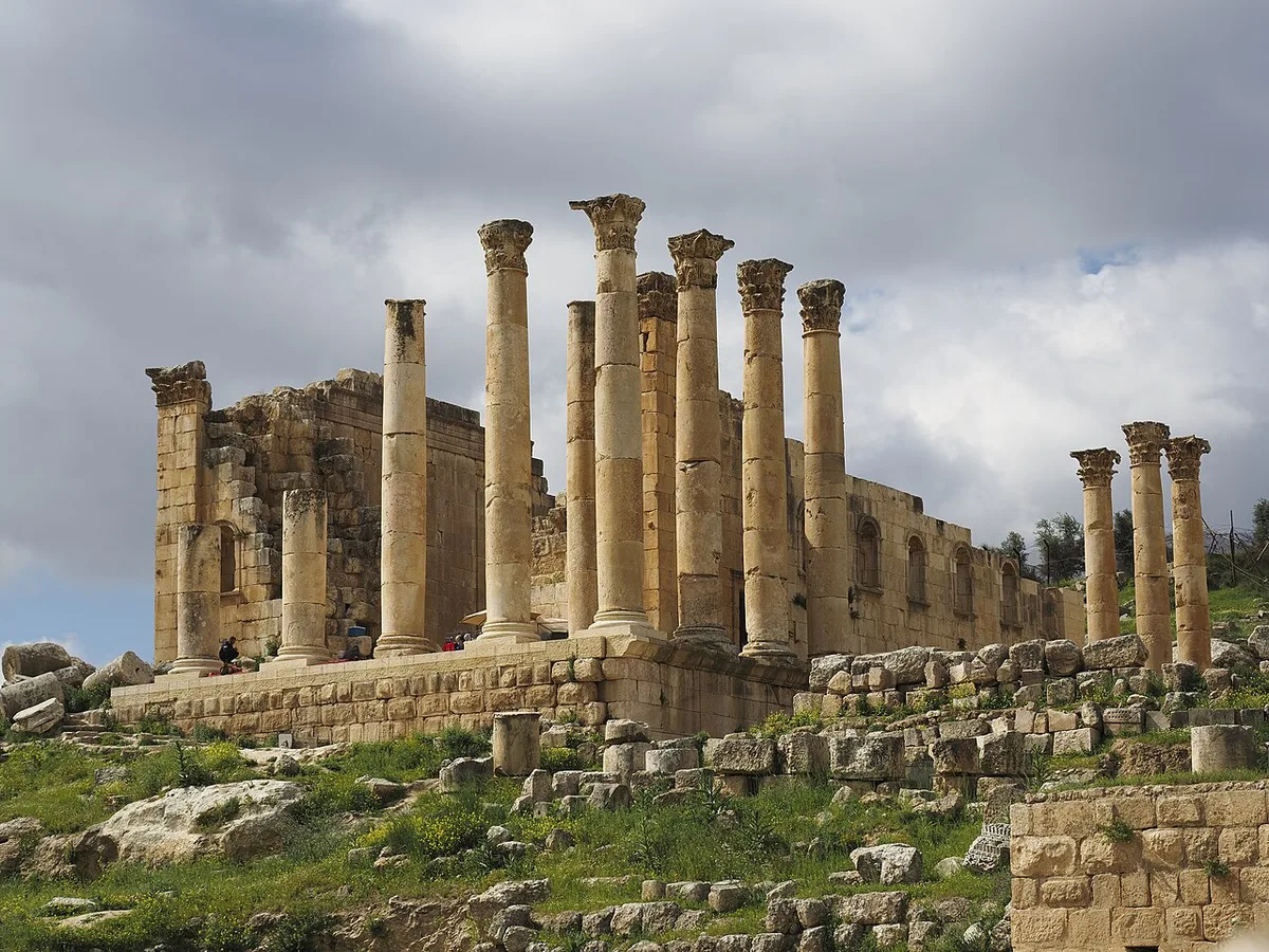
From the Oval Plaza, the ground rises westward to the older of Gerasa’s two great sanctuaries, the Temple of Zeus. Worship on this hill is as old as the Roman city itself – a first sanctuary here dates to AD 27-28, with a Hellenistic predecessor whose traces have been found in the lower courtyard – and the great temple that crowns the upper terrace was built in AD 162-163, raised on vaulted substructures that turned a slope into a platform. The sanctuary climbs over two terraces, and the ascent is part of the architecture – processional, deliberate, lifting the worshipper from the forum’s commerce to the god’s house by stages.
Zeus Olympios was the god of Gerasa’s Semitic population, where Artemis belonged to the Greek tradition – the city’s two communities each kept their patron, and the two temples divided the skyline between them, Zeus above the forum at the south end, Artemis on her higher hill to the north. The Zeus temple is the less complete of the two today, its columns a partial row above the podium, but its position makes it unmissable and its terrace gives the single most useful view on the site: the whole Oval Plaza spread below you, the Cardo’s line running north, and the modern town facing you across the wadi. Every photograph that explains Jerash in one frame is taken from somewhere near this spot.
The pairing says something real about how Gerasa governed itself. This was a city that housed two founding cults without merging them, that let a Greek goddess and a Syrian Zeus share a street plan and a treasury. The Decapolis cities were meeting places of East and West long before UNESCO borrowed the phrase for Jerash’s tentative-list title – the phrase is inscribed in the very name submitted in 2004 – and nowhere is the meeting more visible than from this terrace, with a Semitic god’s temple at your back and a Greek goddess’s columns on the skyline ahead.
The South Theatre and the Whispering Stone
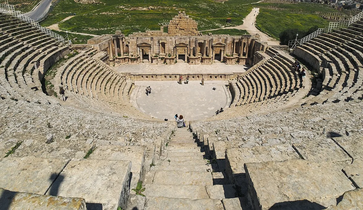
Tucked into the hillside west of the Oval Plaza, a short climb from the Zeus sanctuary, stands the South Theatre, the older and grander of Gerasa’s two theatres. Jordan’s tourism board dates it precisely, to the reign of Domitian, AD 90-92, and gives its capacity as more than 3,000 spectators. The stage building originally rose two storeys; its first level has been reconstructed, and the theatre is not a fossil – it is still used, most prominently during the Jerash Festival each summer, when its seats fill for evening performances under the same sightlines a Domitianic audience enjoyed.
The theatre’s party trick is famous, and it genuinely works. At the centre of the orchestra floor a particular stone marks the acoustic focus of the cavea: a speaker standing on it, talking at ordinary conversational volume, can be heard clearly in the highest rows, the curved banks of seats gathering and carrying the voice the way they were designed to. Guides demonstrate it all day, visitors take turns standing on the stone and murmuring, and the small theatre of strangers listening to each other across two thousand years of architecture is one of the pleasantest rituals on the site. Look, too, at the seats themselves: some are inscribed with Greek letters, the ancient equivalent of reserved-seat numbering, allocating places to the tribes, guilds or dignitaries who had paid for them.
On many days you will also find Jordanian bagpipers in the orchestra – the pipes are a living Jordanian military and celebratory tradition, and the players who station themselves in the South Theatre know exactly what the acoustics do for them. Between the pipers, the guides on the whispering stone, and the occasional school party testing the echo, the South Theatre is the least silent ruin in Jordan. That seems right. Of all Gerasa’s buildings, this is the one whose purpose was sound, and it has never entirely stopped performing it.
The Temple of Artemis, Patron Goddess of Gerasa
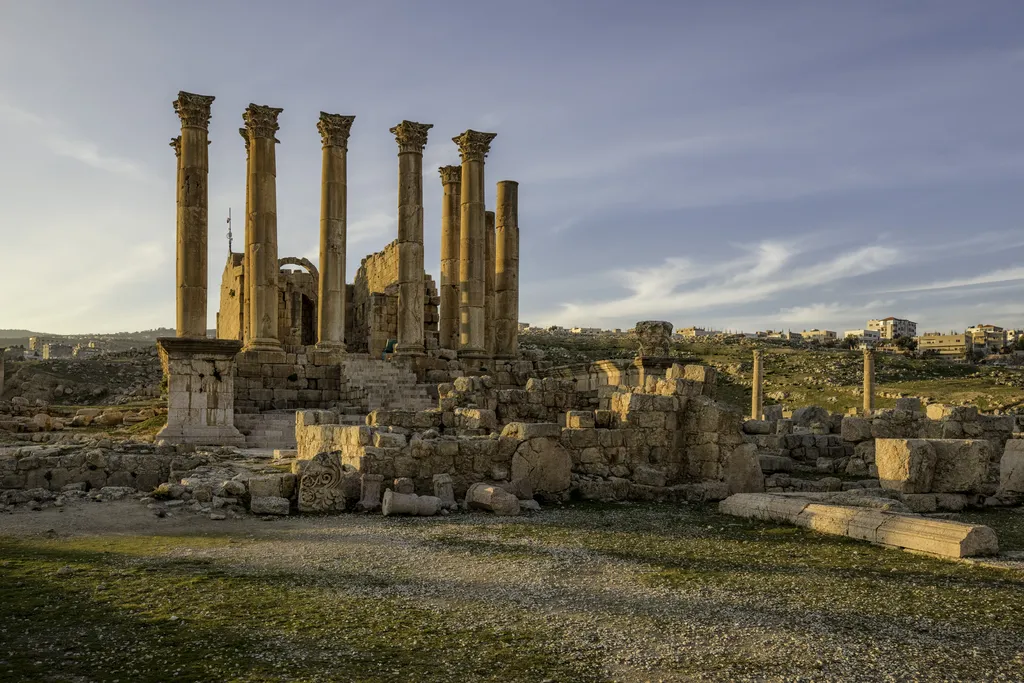
Halfway up the Cardo, a monumental gateway opens westward onto the processional way of the Temple of Artemis, and from that moment the visit changes register – this was the sacred heart of the city, and it was built to slow you down. The way climbs by stages: a broad staircase, a terraced court with its open-air altar, a second staircase, and then the temenos, the great sacred precinct, from which the temple itself rises on its podium. In antiquity the processions began further away still, across the river in the eastern half of Gerasa, and crossed the whole city to reach the goddess – a route that was a piece of theatre in which the entire urban plan took part.
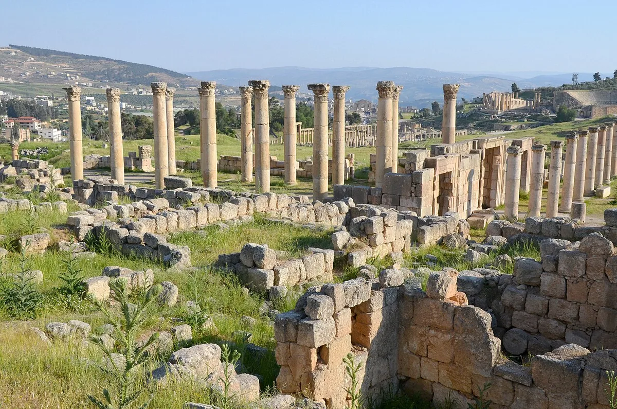
Artemis was the patron goddess of Gerasa, the Greek face of a local deity older than the Greek city, and her temple was the most ambitious building the Gerasenes ever undertook. The sanctuary was rebuilt from AD 136, its propylaeum gateway was completed in AD 150 under the emperor Antoninus Pius – and the temple itself, in a detail this jerash travel guide loves, was never quite finished. The portico was designed for six columns by eleven; eleven columns of the pronaos still stand, over thirteen metres high, their Corinthian capitals so finely carved that they bear the signature of Hygeinos, the contractor responsible for them – a builder signing his work in the second century, confident it would be read. Beneath the podium, vaulted chambers stored the temple’s treasure. The goddess’s house was a bank, a landmark and a statement of identity in one.
Its afterlife compresses the whole history of Jerash into one building. In the late fourth century, when imperial edicts banned the pagan cults, the temple’s marble cladding was stripped and its cella was floored with mosaic and converted into a public reception hall. In the sixth century its roof collapsed and the precinct became an artisanal quarter, with potters’ kilns at work in the courtyard where the processions had formed. The great earthquake of 749 left the columns standing. Standing among them now, the honest feeling is not melancholy but surprise at scale – one of the grandest temples of the Roman East, in a provincial city most travellers reach as a day trip, and on a quiet morning you may have the temenos almost to yourself.
The North Theatre, the Council’s Stage
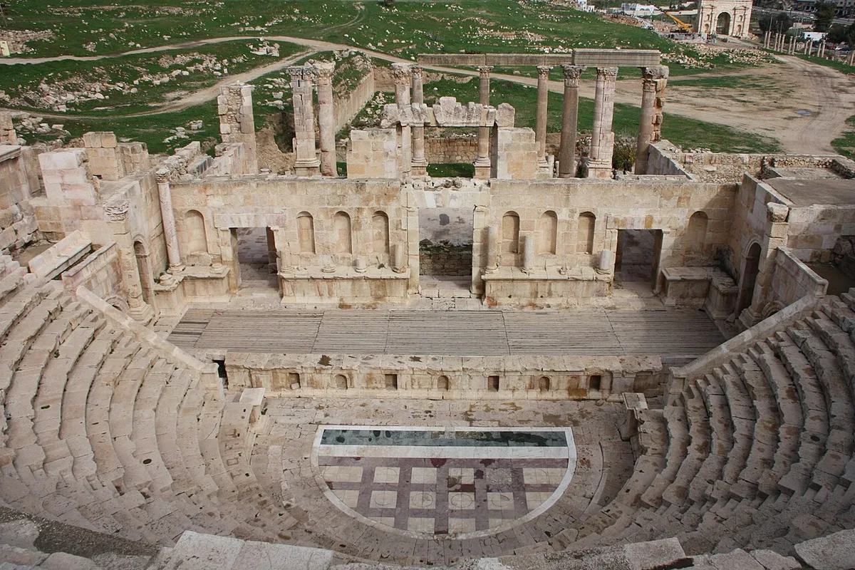
Near the far end of the Cardo stands the second of Gerasa’s theatres, and it is a different animal from its southern sibling. The North Theatre was built in AD 165 with just fourteen rows of seats, and it served a double life: an odeon for music and performance, and the city’s bouleuterion, the council chamber where Gerasa’s citizens’ assembly did its business. In AD 235 the city, still growing, doubled it in size to a capacity of about 1,600 – and within a few centuries it had fallen out of use entirely, its fine stonework quarried for later buildings, which is why it reads today as the more fragile of the two theatres.
Come here after the South Theatre and the contrast teaches you something real about Roman cities: they did not have one entertainment venue but a graded set of them, matched to occasion – the big popular house by the forum for festivals, this smaller, roofed-feeling room for music, poetry and politics, where the audience was also, on council days, the government. The marble paving of its orchestra, laid in coloured geometric patterns, survives in better condition than almost anything of its kind on the site, and the stage building’s columns frame the view south down the Cardo. Late in the day, when the day-trip crowds have gone and the light comes in low from the west, the North Theatre is the quietest grand room in Gerasa.
The North Tetrapylon and the North Gate
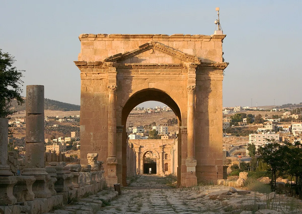
The Cardo ends as ceremonially as it began. Where the northern cross-street, the North Decumanus, cuts the main street, the junction was monumentalised between about AD 165 and 170 with the North Tetrapylon, a domed four-way structure that turned a traffic crossing into a piece of architecture; it was later dedicated to Julia Domna, the Syrian-born wife of the emperor Septimius Severus, whose family would give the empire a dynasty. Tetrapyla are a Decapolis signature – Gerasa has two of them on its main street alone – and they mark the points where the city’s grid acknowledged itself, framing the view in both directions each time you pass.
Beyond the junction, the street narrows to its oldest stretch and delivers you to the North Gate, erected in AD 115 and dedicated, in the inscription on its facade, to the emperor Trajan as founder and saviour of the city. The gate has a quiet engineering secret: it is built slightly wedge-shaped, trapezoidal in plan, so that the road arriving from the north could be bent, almost imperceptibly, into exact alignment with the Cardo. The walls that now flank it came much later – the gate stood free for two centuries before the late Roman wall circuit was built up to meet it. Stand under its arch and you are at the city’s edge, on the road that ran north to the sister cities of the Decapolis in Syria. Most visitors turn back here, and that is the correct instinct: the walk south, down the whole length of the street with the light changed, is a different and better walk than the one up.
The Churches of Byzantine Gerasa
West of the Artemis precinct, on the slope above the Cardo, stands the densest surviving evidence of Gerasa’s Christian centuries: a complex of three churches built between AD 529 and 533, sharing a single atrium – the churches of St John the Baptist, of St George, and of Saints Cosmas and Damian. They are the most visited of the city’s churches because of what lies underfoot. Gerasa’s Byzantine congregations floored their churches with mosaics, and several of these floors survive in a condition that makes Madaba, Jordan’s famous mosaic town, a fair comparison.
The floors repay slow looking. St John’s mosaics picture holy cities – Alexandria and Memphis among them, labelled in Greek, a map of the Christian world laid in stone tesserae. St George’s floor carries the scars of the eighth-century iconoclasm, when images of living beings in church floors were systematically defaced by believers who had come to see them as idolatry; its figures were picked out and the gaps patched with plain patterning. And then there is the third church of the group, whose floor survived almost intact precisely because the building fell early and buried it – destruction as preservation, the same accident that saved the whole city.
These were not the only churches, not by a long way. Counting the cathedral complex by the Cardo, the Propylaea Church built beside the Artemis gateway in the sixth century, and the church of Bishop Isaiah of the 550s, Gerasa had at least fourteen churches between the fourth and seventh centuries – this jerash travel guide has room for only the greatest hits. Beneath one of them, the church built around AD 530 now called the Synagogue Church, excavators found an earlier mosaic floor carrying inscriptions in Greek and Hebrew-Aramaic: a synagogue, converted. Pagan temple, synagogue, church, mosque – Gerasa’s sacred buildings kept changing hands and faiths, and the floors are where the handovers are documented.
Saints Cosmas and Damian, the Floor That Survived
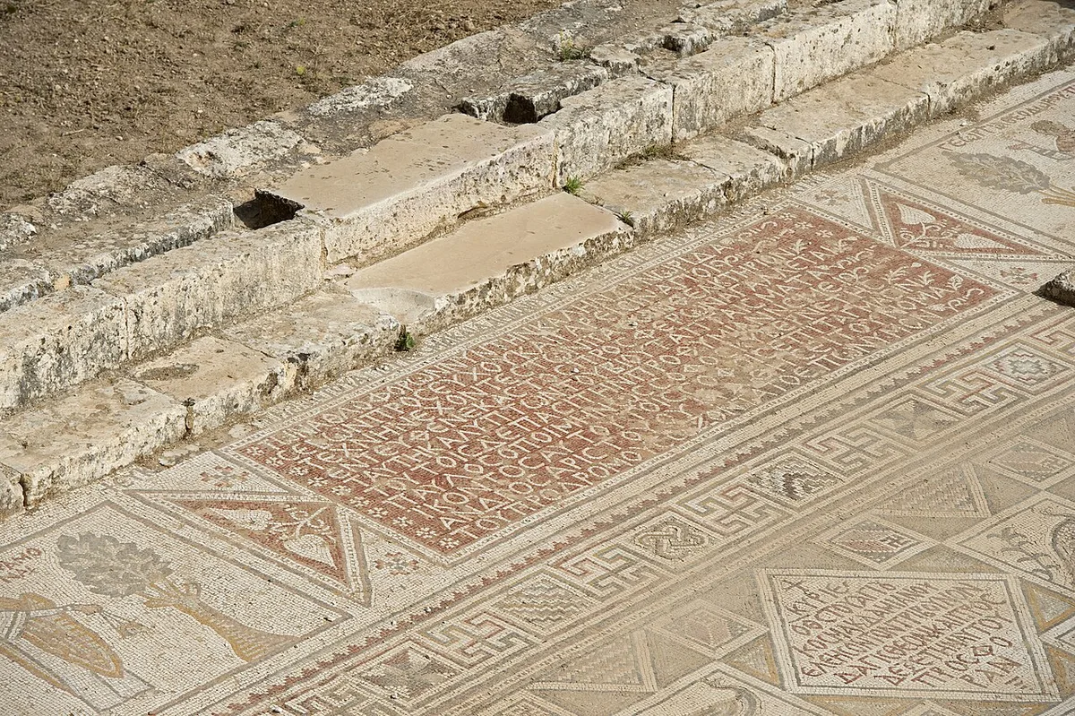
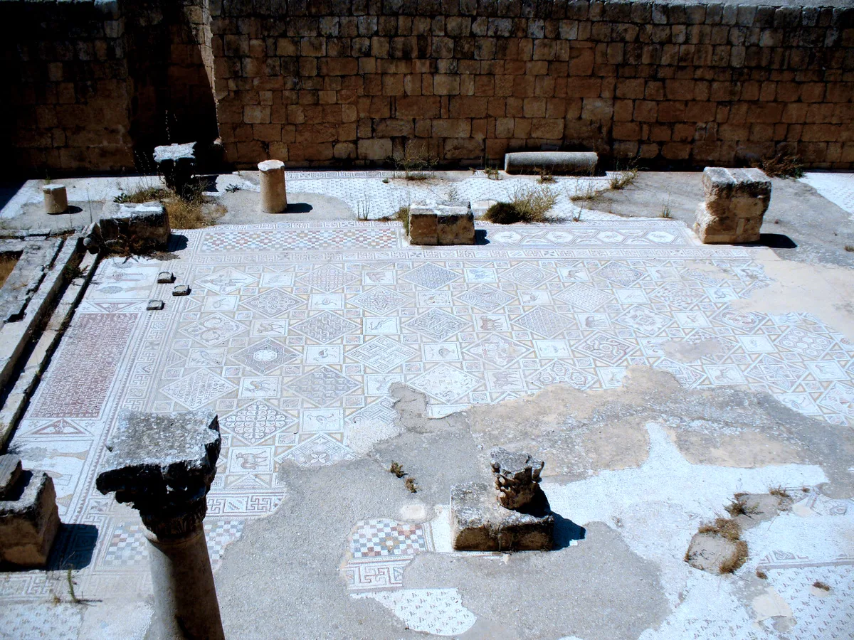
The Church of Saints Cosmas and Damian deserves its own section because its floor is, by common consent, the finest mosaic in the city. Cosmas and Damian were twin brothers, physicians who treated the sick without payment and were martyred for their faith – exactly the patrons a sixth-century congregation would choose for a church concerned with healing, and their church, built in AD 533 within the three-church complex, received the group’s masterpiece: a floor organised as a great grid of diamond panels, each containing a bird, an animal, a vase of flowers or a human figure, the whole carpet bordered with interlace and inscription.
Its most touching panels picture the church’s own community – the donors who paid for the floor and the clergy who served it, rendered at small scale among the peacocks and gazelles, their names lettered beside them in Greek. A floor like this is a congregational photograph: the Gerasenes of AD 533 commissioned their portraits in stone, in the house of the physician saints, and the portraits outlasted the empire, the caliphate, the earthquake and the twelve centuries of burial. The great inscription panel, set where the congregation entered, records the dedication in formal verse – the floor literally introduces itself, and reading even a few words of it through the Greek, with a guide’s help, collapses the distance between their city and your visit more completely than any column can.
Practical looking takes a moment of discipline: the mosaics are viewed from the church’s edges and from raised positions at its sides, never walked on, and the light is best before the sun gets high and flattens the colours. Go to the three churches in the morning if your route allows, or accept the raking late-afternoon light. Either way, do not let a Jerash visit end without them. The columns get the postcards, but the floors are where Gerasa actually speaks.
The Other Jerash, the Town Across the Wadi
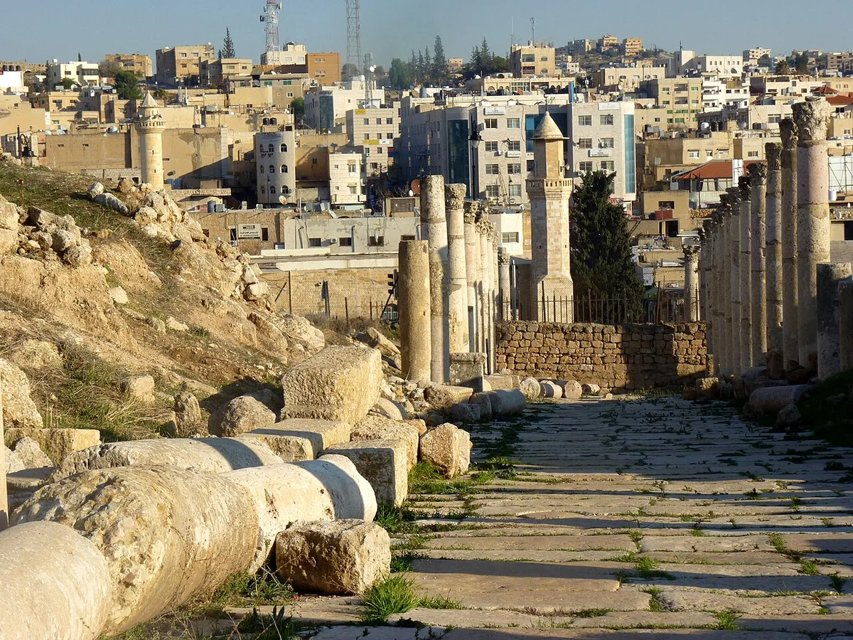
Every account of Jerash, including this one, spends most of its words on the dead city. But Jerash is also a living Jordanian town of some fifty thousand people – 50,745 at the 2015 census – the capital of its governorate, and the ruins cover only its western half. The stream in the wadi, the Chrysorrhoas whose Greek name gave Gerasa its grand title, divides the two: archaeological park on the west bank, apartment blocks, schools, workshops and markets on the east. The minaret you can see from the Cardo is the town’s, the call to prayer drifts across the ruins at midday, and the relationship between the two Jerashes is the reason the ancient one survives. Because the Circassian village of 1878 grew on the far bank, the forum and temples were never built over, quarried into a living town’s foundations or lost under suburbs. The modern town is not the ruins’ rival. It is their bodyguard, and has been for a century and a half.
The town’s population carries its layered history in its surnames – Circassian families descended from the nineteenth-century settlers, Jordanian families of the valley, and later waves including Palestinian refugees, whose camps at Souf and outside the town are part of the governorate’s modern story. For the visitor, the practical consequence is simple and worth acting on: the dead city has the monuments, but the living one has lunch. The restaurants and bakeries on the town side of the site entrance serve the Jordanian standards – grills, flatbreads, salads, mint tea – to a mixed crowd of locals and travellers, and eating there puts your money into the town that hosts the ruins rather than into a tour-bus buffet. Jordan’s tourism board also points visitors to the Jerash Archaeological Museum, founded in 1923 in a vault of the Artemis temple courtyard and rehoused since 1985 near the site, whose displays run from the Neolithic to the Mamluk period, including the Zeus and Aphrodite statues found in the Eastern Baths excavations of 2016. Twenty minutes in the museum before the walk genuinely sharpens the walk.
Do not expect the town to be picturesque, and do not hold that against it. It is a working provincial centre that happens to stand beside one of the great archaeological sites of the world, and the contrast is the honest truth of tourism in Jordan: the visitors come for two thousand years ago, and fifty thousand people get on with this week in its shadow. Crossing the bridge for a meal, a coffee and a wander through the market streets is the cheapest act of respect available to you, and it completes the picture this jerash travel guide has been drawing all along – Gerasa was always a living city first. It still is. Only the name over the gate has changed.
One Northern Day, Jerash With Ajloun and Amman
Jerash sits 48 kilometres north of Amman on the main northern highway, and the journey is part of the day’s pleasure – the road climbs out of the capital into the greenest country in Jordan, a landscape of olive terraces, pine woods and stone villages that surprises everyone who arrived expecting only desert. Most visitors come by rental car, by private driver hired for the day, or on an organised tour; public buses also link Amman and Jerash through the day from the capital’s northern bus station, and service taxis cover the same ground. This guide prints no fares – they change, and the honest mechanism is what matters: agree any taxi fare before the door closes, and if you are driving yourself, the site is signed from the highway and parking sits by the visitor entrance. Allow roughly an hour from central Amman in normal traffic.
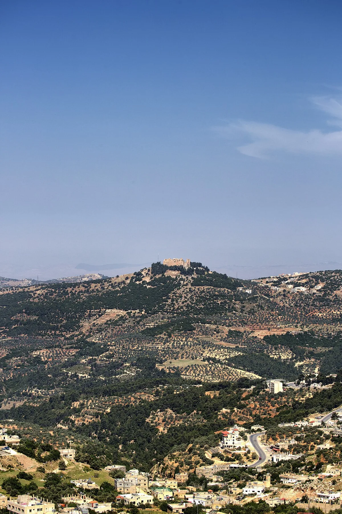
The pairing that northern Jordan seems designed for is Jerash in the morning and Ajloun in the afternoon. About half an hour’s drive west of Jerash, through olive country, Ajloun Castle – Qal’at ar-Rabad – crowns a forested hilltop above the town of Ajloun. It is a fortress of the other side of Jordan’s medieval story: begun in 1184-85 by Izz al-Din Usama, one of Saladin’s emirs, and enlarged in 1214-15, it was built to watch the three wadis that descend to the Jordan Valley, to guard the district’s iron mines and the Damascus road, and to face the Crusader castle of Belvoir across the valley. From its towers the view runs west over the valley to the hills beyond – on a clear day, a geography lesson in a single glance. A small museum sits inside its vaulted halls. Roman city in the morning, Ayyubid castle in the afternoon: two thousand years of Jordanian history, one tank of petrol, and the contrast between the Decapolis and the age of Saladin makes a trip cohere.
Amman itself is the third corner of the day, and the arithmetic is flexible. Jerash plus Amman’s Citadel and Roman Theatre makes a full but civilised day for travellers based in the capital; Jerash plus Ajloun suits those heading north or looping back late; all three is possible and is a rush – you would be short-changing the Cardo, which deserves its slow hour. Our 7-day Jordan itinerary places Jerash where it belongs in a first week, as the northern day between Amman and the drive south to Petra, and the site’s roundup of the best places to visit in Jordan puts it in its national context. However you arrange it, get the money question settled before you go: admission to the Jerash archaeological city is included in the Jordan Pass, Jordan’s official sightseeing pass, which bundles a waiver of the tourist visa fee with entry to the country’s main sites, Petra included. If you are touring Jordan for more than a couple of days the pass is usually the rational purchase; buy it before you arrive in the country, since the visa-fee waiver only applies when the pass is bought in advance. Prices are not printed here – check the current cost and terms on the official Jordan Pass site when you plan.
When to Go, Spring Flowers Against Summer Stone
Jerash has a hot-summer Mediterranean climate and sits about 600 metres above the sea, which takes the worst edge off the Jordanian summer without abolishing it. Long-term averages put the July and August daytime maximum around 31 degrees, January’s around 13; the rain falls between November and March, and high summer is bone dry. Within those numbers, the seasons divide the site into quite different places, and choosing yours is the single easiest way to improve the visit.
Spring, from March to May, is the connoisseur’s answer. The hills around the ruins are green, wildflowers come up between the paving stones of the Cardo – anemones, poppies, cyclamen and dark irises – and the temperatures run from mild to warm rather than hot. The famous photographs of Jerash, the ones with colour in the foreground and honey-coloured stone behind, are spring photographs, and the site in April can feel less like a ruin than a garden that a city happened to grow in. Autumn, September to November, runs it close: the heat breaks, the light turns low and golden, the crowds thin after the summer, and the stone holds the day’s warmth into the evening. Winter is the connoisseur’s gamble – cold wind off the hills, rain that can turn the site dramatic and empty, mud in the unpaved quarters, and the whole Cardo to yourself between showers; dress for it and it has a bleak grandeur, but it is not the Jerash of the brochures.
Summer demands honesty, which the downsides section below gives it in full; here it is enough to say that a July visit is a logistics exercise – enter at opening time, walk the Cardo in the morning, and be in the shade of a restaurant by one. One summer institution deserves its own mention. Since 1981 the Jerash Festival of Culture and Arts has filled the ancient city each year in late July and early August, with concerts, dance, poetry and theatre staged in the South and North Theatres and across the plazas; recent editions have even turned the hippodrome into a performance stage, so that the arena built for chariots hosts folklore troupes two millennia on. If your dates collide with the festival, go in the evening – the ruins floodlit, the theatres working again, the Oval Plaza full – and forgive the heat for one night.
The Honest Downsides of Jerash
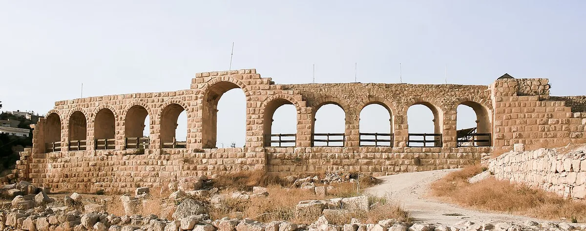
A guide that only sells Jerash is a brochure, so here is the other ledger, and it begins with the sun. The archaeological park offers almost no shade. The Cardo is an 800-metre stone corridor that collects heat and gives it back; the plazas are open to the sky; the temples stand on bare terraces. From June to September, a midday visit is not merely uncomfortable but a genuine physical undertaking, and even in spring the reflected light off pale limestone is fierce by noon. The defences are boring and effective: arrive at opening time, carry more water than you think you need – there is nowhere inside the fence to refill your bottle – and treat a hat as equipment, not an accessory. The second item is timing of a different kind. Jerash is a fixture of every Jordan itinerary, and the organised groups arrive in waves from mid-morning: between about ten and one, the Oval Plaza and the South Theatre can feel like a railway station. The same site at eight in the morning, or after three in the afternoon, is a different and far better place.
The ground itself asks for respect. The Cardo’s ruts and diagonal slabs, the very features you came to see, are trip hazards underfoot, the climb to the Zeus and Artemis terraces is stepped and uneven, and large parts of the northern quarters are rough ruin-field rather than pavement; this is not a site for sandals or for anyone unsteady on broken stone. Signage on the ground is thinner than the site deserves, which is why the visitor centre and museum come first in this guide – context gathered there doubles the value of the walk. Around the theatres and the plaza you will be offered guiding, photographs and small souvenirs with varying degrees of persistence; it rarely rises above the good-humoured, and a polite refusal is understood at once. And finally, manage the chariot-show expectation as the hippodrome section advised: the re-enactments are real and worth seeing, but they do not run to a timetable you can plan a day around from abroad. None of this outweighs the place. Jerash survives its downsides the way it survived its earthquake – substantially, and still standing.
Frequently Asked Questions
Is Jerash a UNESCO World Heritage Site?
No. Jerash is on UNESCO’s Tentative List – Jordan submitted “Jerash Archaeological City (Ancient Meeting Place of East and West)” in January 2004, under criteria (iii) and (iv) – which makes it a candidate for inscription, not an inscribed World Heritage Site. The distinction costs the ruins nothing; they are among the finest Roman remains in the world on their own evidence.
How long do you need at Jerash?
Half a day is the honest minimum. The walk from Hadrian’s Arch to the North Gate and back, with real time at the theatres, the Artemis temple and the mosaic churches, takes three to four hours on site; add the museum and you have earned lunch. Travellers who give it ninety minutes see the plaza and the street and miss the point, which is the accumulation of the whole city.
Is Jerash included in the Jordan Pass?
Yes. Jordan’s tourism board states plainly that admission to the Jerash Archaeological City is included in the Jordan Pass, the official pass that bundles entry to the country’s main attractions with a waiver of the tourist visa fee for travellers who buy it before arrival. Check the current price and terms on the official Jordan Pass website when you plan – this jerash travel guide prints no prices, because they change and old ones mislead.
How do you get to Jerash from Amman?
Jerash is 48 km north of the capital, roughly an hour by road. The realistic options are a rental car, a private driver for the day, an organised day tour, or the public buses and service taxis that link Amman with Jerash through the day from the capital’s northern bus station. Agree any taxi fare before you set off, and start early – the site rewards the first hours of the day.
When is the best time to visit Jerash?
March to May, if you can choose: mild temperatures, green hills, and wildflowers between the paving stones. September to November is the second-best window, warm and golden. December to February is cold, sometimes wet, and wonderfully empty. June to August is fiercely sunny – go at opening time or not at all. The Jerash Festival fills the theatres with evening performances in late July and early August.
Is the chariot racing show running?
The Roman Army and Chariot Experience stages legionary drill, gladiator bouts and seven-lap chariot races in the hippodrome, and Jordan’s tourism board lists the performances among the site’s regular attractions. Performance days and times vary with the season, however, and are not published in a form this guide can guarantee – ask at the visitor centre when you arrive, and treat the show as a prize if it is on, not as a promise.
Can you visit Jerash and Petra in one day?
You can, in the sense that roads exist, and you should not. Jerash is an hour north of Amman and Petra is three hours south; the combination produces two hurried walks and a day inside a car. Jerash belongs to the northern day – with Amman or Ajloun – and Petra deserves its own full day, ideally two. Our Jordan itinerary sequences them properly.
Is Jerash worth it if you have already seen Rome?
Yes, and arguably especially then. Rome gives you the empire’s monuments in glorious isolation; Jerash gives you something Rome itself no longer can – an entire provincial city in its working order, street, drains, shops, theatres, temples and churches on one walkable plan, built by local wealth rather than imperial command. It is the empire as a system rather than as a set of trophies, and it changes what the famous ruins elsewhere mean.
The Short Version of This Jerash Travel Guide
Jerash is Gerasa, a Greek-founded city of the Decapolis that Rome’s peace made rich, an earthquake in 749 half-buried, and shepherds, farmers and archaeologists between them preserved – a Roman provincial capital standing almost complete in its valley 48 km north of Amman, and a candidate on UNESCO’s Tentative List rather than an inscribed World Heritage Site, whatever the brochures say. Walk it the way this jerash travel guide has: Hadrian’s Arch and the hippodrome outside the walls, the South Gate into the Oval Plaza, then the full length of the rutted, colonnaded Cardo past the Nymphaeum and the cathedral steps, up to the Temple of Artemis, the two theatres for the two halves of the city’s public life, the North Gate for the full stop, and the mosaic floors of Saints Cosmas and Damian for the moment the city stops being architecture and starts being people. Cross the wadi for lunch in the living town, pair the day with Ajloun Castle if you can, come in spring if you can manage it, come early in the day whatever the season – and give the Roman city that outlived its empire the unhurried half-day it has earned nineteen times over.